Ask the Expert
Amanda Lohmann
Data scientist, vessel tracking and behavior

What information can be accessed in the public apparent fishing effort dataset and what has changed in the latest release?
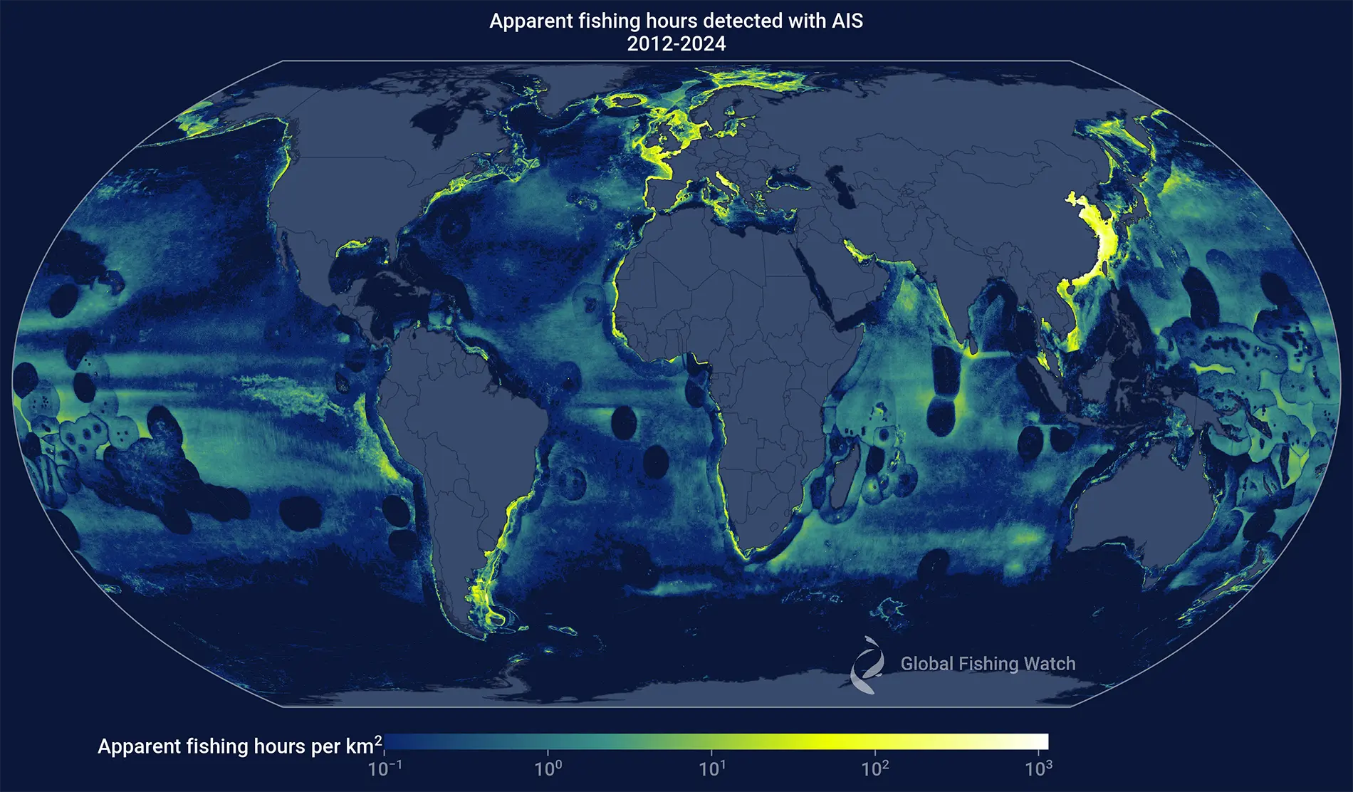
Global Fishing Watch released its first public dataset of apparent fishing effort in 2018, providing a view of global fishing activity. Still used today, this flagship dataset shows fishing hours calculated using positions broadcasted through vessels’ automatic identification system (AIS). Since we classify vessel behavior using machine learning algorithms rather than direct observation, we refer to this metric as “apparent fishing hours.”
The apparent fishing effort data are intended to allow users to analyze patterns of daily fishing activity across the ocean. Fishing can be separated out by gear type, flag and other vessel characteristics such as tonnage.
We just released the third installment of this dataset, which covers 2012 through 2024. This adds four additional years of data with nearly 370 million hours of fishing activity by over 141,000 unique maritime mobile service identity (MMSI) numbers that act as international identifiers for vessels, which are broadcast in AIS messages. Collectively, the full dataset now includes approximately 695 million fishing hours by more than 192,000 unique MMSI.
Over the past few years our dedicated team of data scientists, analysts, engineers, research partners and fisheries experts have updated and improved our data processing and models. We have also added over 20 new vessel registry sources, doubling the number of MMSI with registry information, and improved the coverage of our AIS data by adding more terrestrial AIS data from Marine Traffic and additional satellite and dynamic AIS data from Spire Global.
With these updates, users may notice some changes. Here are a few of the highlights.
Fishing hours and vessel classification have been updated
With improvements to our algorithms, expanded vessel registry integration and a longer AIS timeseries, we are able to better identify fishing vessels, assign gear types and estimate fishing hours. Therefore, apparent fishing hours and vessel classification look slightly different in this release than in previous releases.
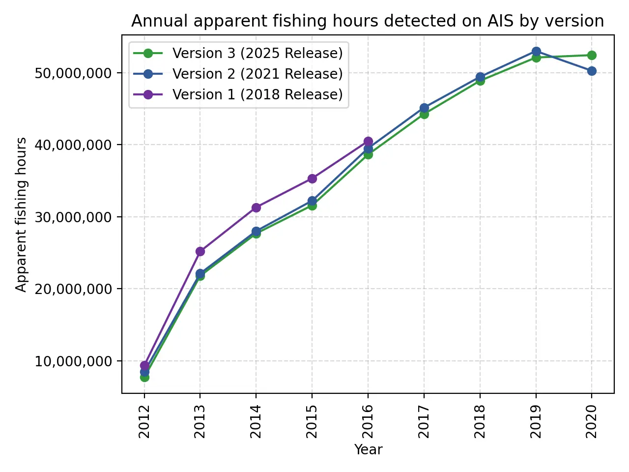
Total global apparent fishing hours are quite similar between this release and the previous release. In most years, this release, defined as version 3, shows a 2 percent decrease in total annual fishing hours from the previous release, or version 2. This drop is primarily the result of improvements to our AIS processing algorithms, which remove unreliable data and provide our models with clean vessel tracks. The bigger change in 2020 occurs because version 2 was released shortly after the close of that year and some vessels new to the AIS data in 2020 did not have sufficient data for our models. As more data were collected and integrated in 2021, we were able to identify these vessels as fishing vessels and detect their fishing activity. For the same reason, data provided in this release for 2024 are provisional as they may change noticeably as more data from 2025 become available.
The list of vessels included in this release, and the gear types assigned to those vessels, has some changes from the previous release as more data has shifted our classifications of certain MMSI. The additional four years of AIS data may result in a different vessel classification from our machine learning model for certain MMSI, while changes to other MMSI may be due to newly available vessel registry information. Individual MMSI are only included in this dataset if we have strong evidence that the MMSI is associated with a fishing vessel, and if the MMSI meets baseline requirements for activity — more than 5 days — and fishing hours — more than 24 hours — in a given year.
Lastly, this dataset uses MMSI as the vessel identifier and provides a single set of information for each MMSI by using our vessel identity algorithms to combine multiple sources of information. However, in practice, vessels can change MMSI numbers and the information associated with an MMSI may not always match other sources you might find. Tracking a vessel’s identity over time is an active area of research here at Global Fishing Watch as we work to publish data with improved vessel identifiers in the future.
New labels for vessels with unknown flag State
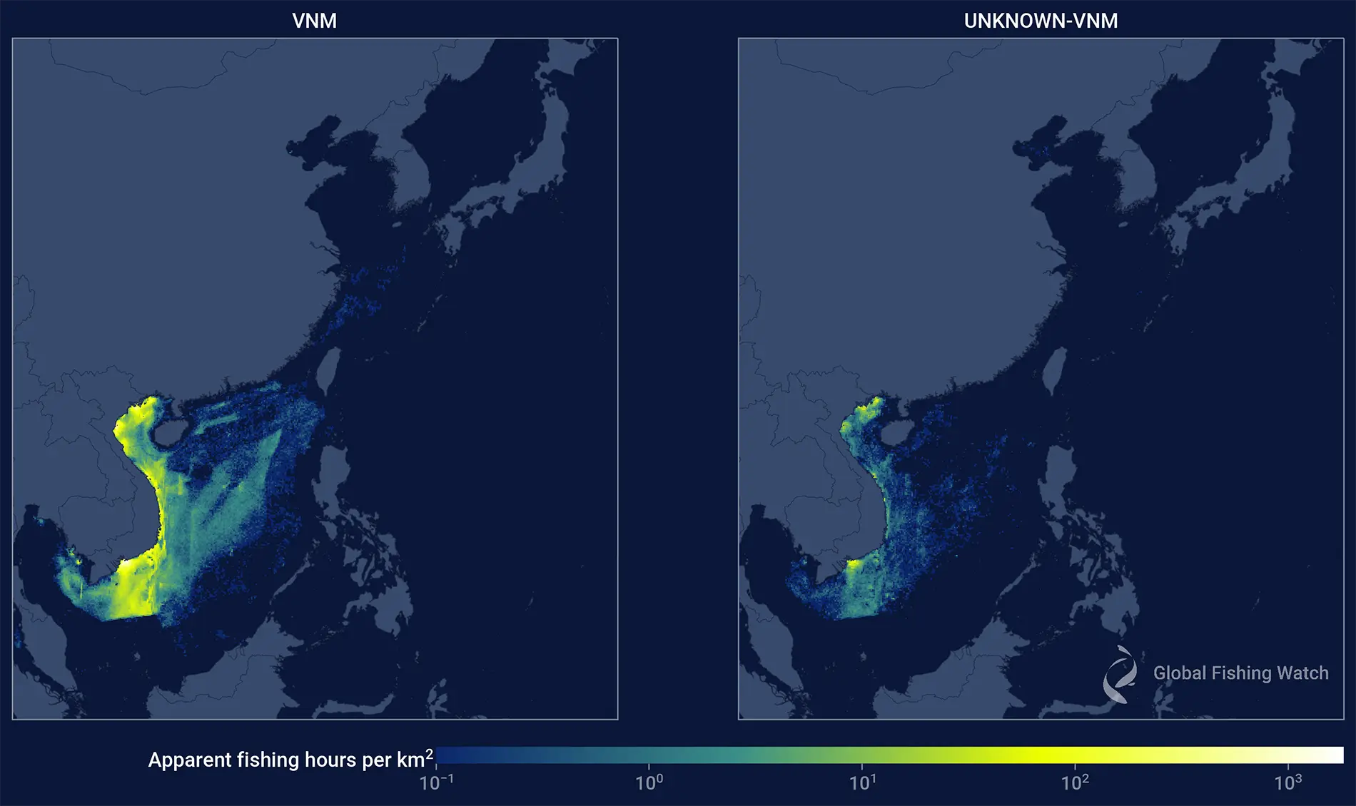
AIS data uses the first three digits of an MMSI, known as maritime identification digits (MID), to indicate a vessel’s flag State, but since operators manually input MMSI codes, errors are common. Invalid MID codes can obscure a vessel’s flag State, affecting thousands of MMSI in the dataset, the vast majority of which operate almost exclusively in the waters around East Asia.
Previously, some MMSI with invalid or incorrect MID codes were reassigned to China or Chinese Taipei based on activity patterns, given that strict enforcement makes it highly likely that vessels operating in this area are associated with these flags.
However, to ensure consistency and transparency, the new dataset no longer reassigns MMSI with valid MID codes. For invalid MID codes, the flag is either labeled as UNKNOWN or, if the vessel spent over 50 percent of its time in a single EEZ, its flag is labeled UNKNOWN-[ISO3] with the ISO code corresponding to that EEZ. This change improves clarity and expands the list of potential vessels for each flag State.
Dynamic AIS has dramatically increased the activity we see in recent years
Dynamic AIS (D-AIS) is a new form of AIS technology designed to address the issue of poor satellite AIS reception. In areas of high vessel density, AIS messages interfere with one another, reducing the number received by satellites. To get around this challenge, thousands of large vessels traveling throughout the busiest shipping lanes in the world are now equipped with D-AIS receivers that record AIS messages of nearby vessels and relay them to satellites.
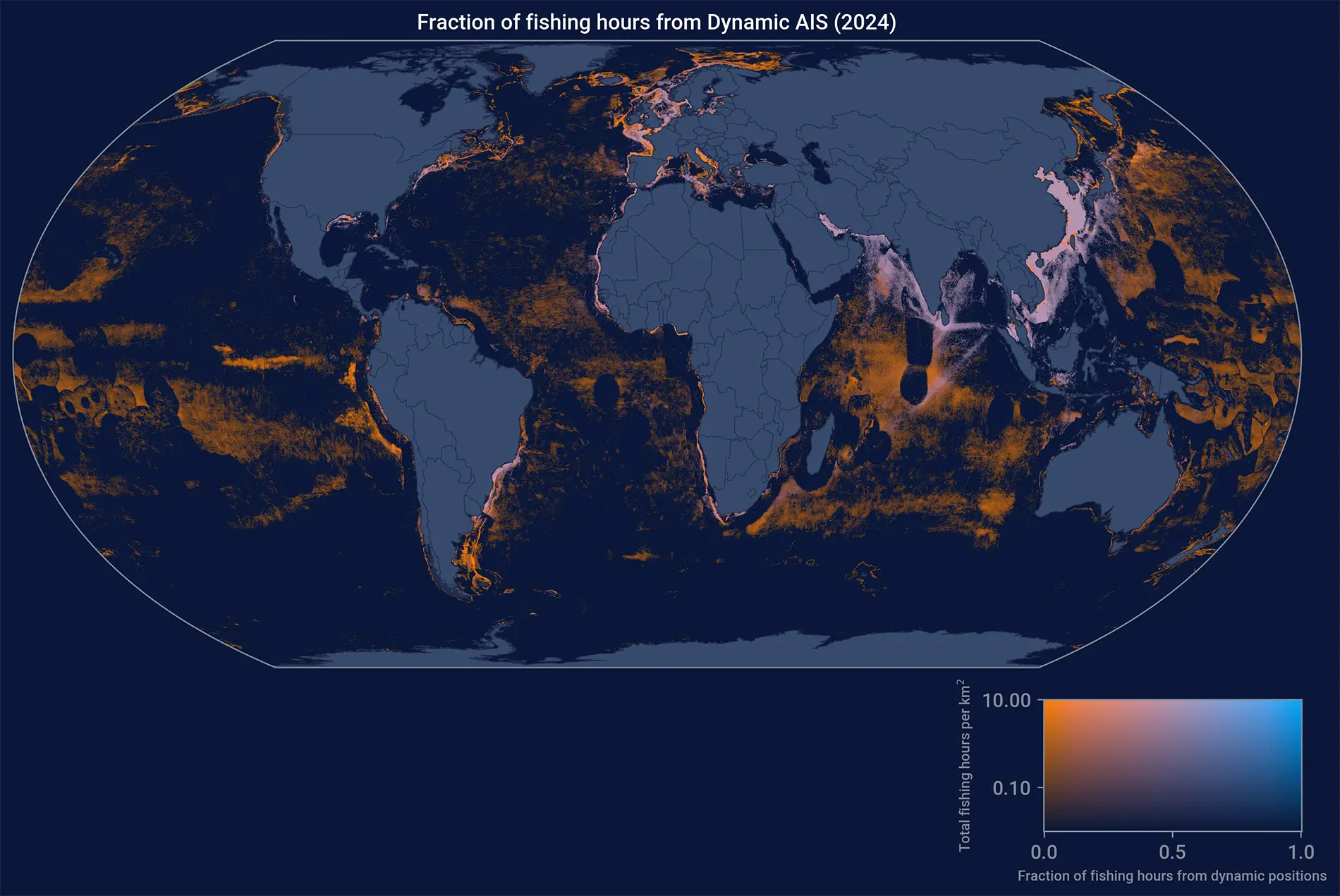
Because of dynamic AIS, we are now receiving much more AIS data from areas that previously had limited AIS coverage in our data. This change is particularly apparent in Southeast Asia. We expect that the major increases in apparent fishing effort in recent years in these areas can be attributed to this improvement in AIS reception. To support researchers with understanding these changes, we are working on creating a separate dataset on AIS reception.
Global Fishing Watch aims to support sustainable ocean management by making human activity at sea visible. To this end, the datasets we create are open access. We are excited to share our updated AIS Apparent Fishing Effort dataset and welcome your input and feedback.