Global Fishing Watch is using radar data to detect fishing vessels hidden from monitoring systems
Global Fishing Watch is working to transform fisheries governance by harnessing satellite data to publicly show the movements of fishing vessels. A key data source for detecting apparent global fishing activity is satellite automatic identification system, or AIS—a collision avoidance system that constantly transmits a vessel’s location at sea.
While AIS data is revolutionizing ocean monitoring and demonstrating the value of transparency, it is carried by only a small fraction of the world’s roughly 2.8 million fishing vessels. Many smaller vessels don’t have trackers fitted. And vessels are known to switch off their AIS devices—known as “going dark”—or tamper with them to shield illicit activities.
If we can’t detect these vessels, then we’re only seeing part of the picture.
In the Mediterranean and Black Sea region, we’re exploring how we can address this issue through the use of satellite radar technology. And the results so far are striking.
The need for monitoring
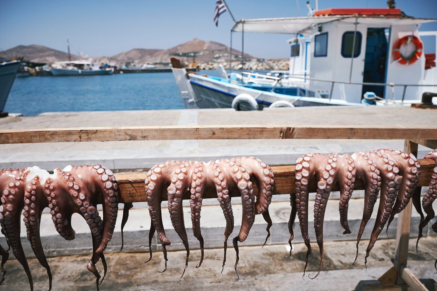
Fishing is vital to the economy and the culture of the Mediterranean. Somebody fishes in every single village around the coast of the Mediterranean and Black Sea, and the industry contributes an estimated US$9.4 billion to the region’s economy every year.
But better fisheries management is an urgent priority. Three-quarters of Mediterranean and Black Sea stocks are being fished beyond sustainable limits, threatening unique biodiversity and the long-term viability of many fishing communities.
Good fisheries management depends on good information. Governments and regional fisheries bodies need to know who’s fishing where and what they’re catching in order to develop effective policies. And they need to be able to monitor whether vessels are complying with the rules and take action where they aren’t.
In the Mediterranean and Black Sea, this is particularly challenging because of the large number and small size of the vessels involved. Small-scale fishing boats make up 83 percent of the Mediterranean and Black Sea fishing fleet—some 71,400 vessels—and many of these don’t have tracking systems installed, and there is no requirement for AIS on all fishing vessels operating in the region. In addition, not all countries in the region operate a vessel monitoring system (VMS), which is required by many governments around the world. VMS tracks vessels in a similar way to AIS, but access has historically been restricted to government regulators or other fisheries authorities. A growing number of governments are publishing their VMS in collaboration with Global Fishing Watch, but this is not yet the case in the Mediterranean and Black Sea.
As a result, publicly available tracking information from vessels operating in the Mediterranean and Black Sea is patchy, particularly outside of European coastal waters, and so analysis shows a fair amount of fishing activity within European waters, but little elsewhere. And yet, many non-European countries significantly contribute to the capture production of the Mediterranean and Black Sea region.
Vessel detection
Radar imagery is one way to identify fishing vessels that don’t show up on AIS. Satellite radar emits pulses of radio waves and then measures how these waves bounce off the earth. The timing and frequency with which the waves return allow us to make an “image” of the surface of the earth. Some materials reflect radar signals better than others. Metal, for example, is a great reflector, while sea water isn’t – so a metal boat clearly shows up against the surface of the sea. It can also detect signals through cloud cover and in most weather conditions.
We used publicly available synthetic aperture radar, or SAR, imagery from the European Space Agency Sentinel-1 satellite, which regularly passes over the Mediterranean and Black Sea. Using machine learning techniques to automate the analysis, we were able to identify the presence of most fishing vessels larger than 15m in length and compare this with vessels that do broadcast their positions over AIS.
Once we’d filtered out the noise—commercial shipping lanes, static objects, vessels unlikely to be engaged in fishing activity because of their location—a clear picture emerged of the scale of the “dark fleet”—vessels that do not publicly broadcast their location or appear in public monitoring systems.
When looking at AIS data alone, large areas of the Mediterranean and Black Sea appear to be free of any fishing activity. But add in the SAR data, and many more vessels appear, particularly in the waters of North African and Eastern Mediterranean coastal States. These extra vessels suggest that there are many commercial vessels operating in the region that don’t use AIS and are not broadcasting their activity. In addition, some of these unmatched vessels might have AIS but have it turned off, or they may be broadcasting AIS in a region with poor AIS reception. However, most are likely vessels that do not have AIS.
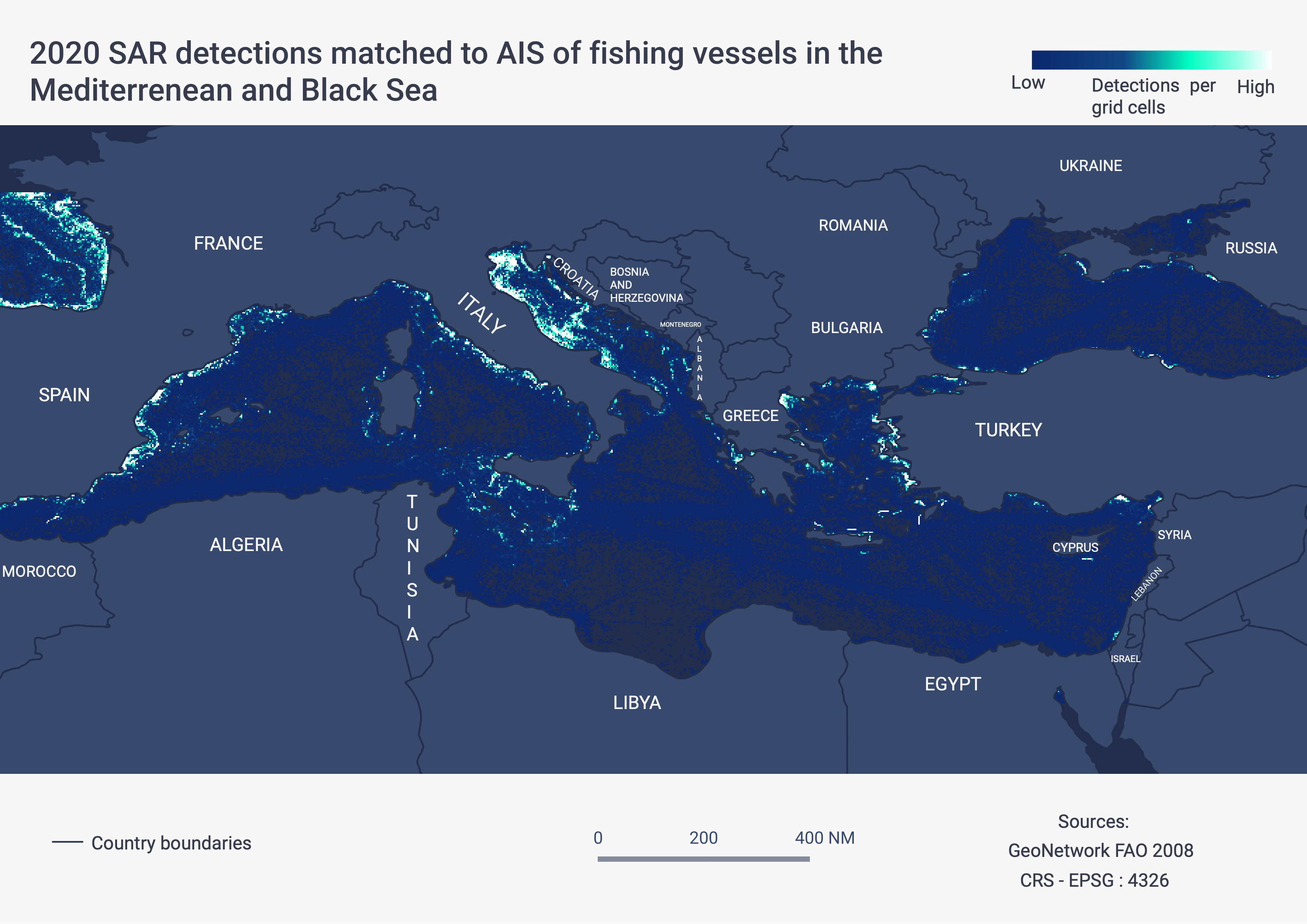
Figure 1. Vessels detected with SAR and matched to fishing vessel AIS in the Mediterranean and Black Sea.
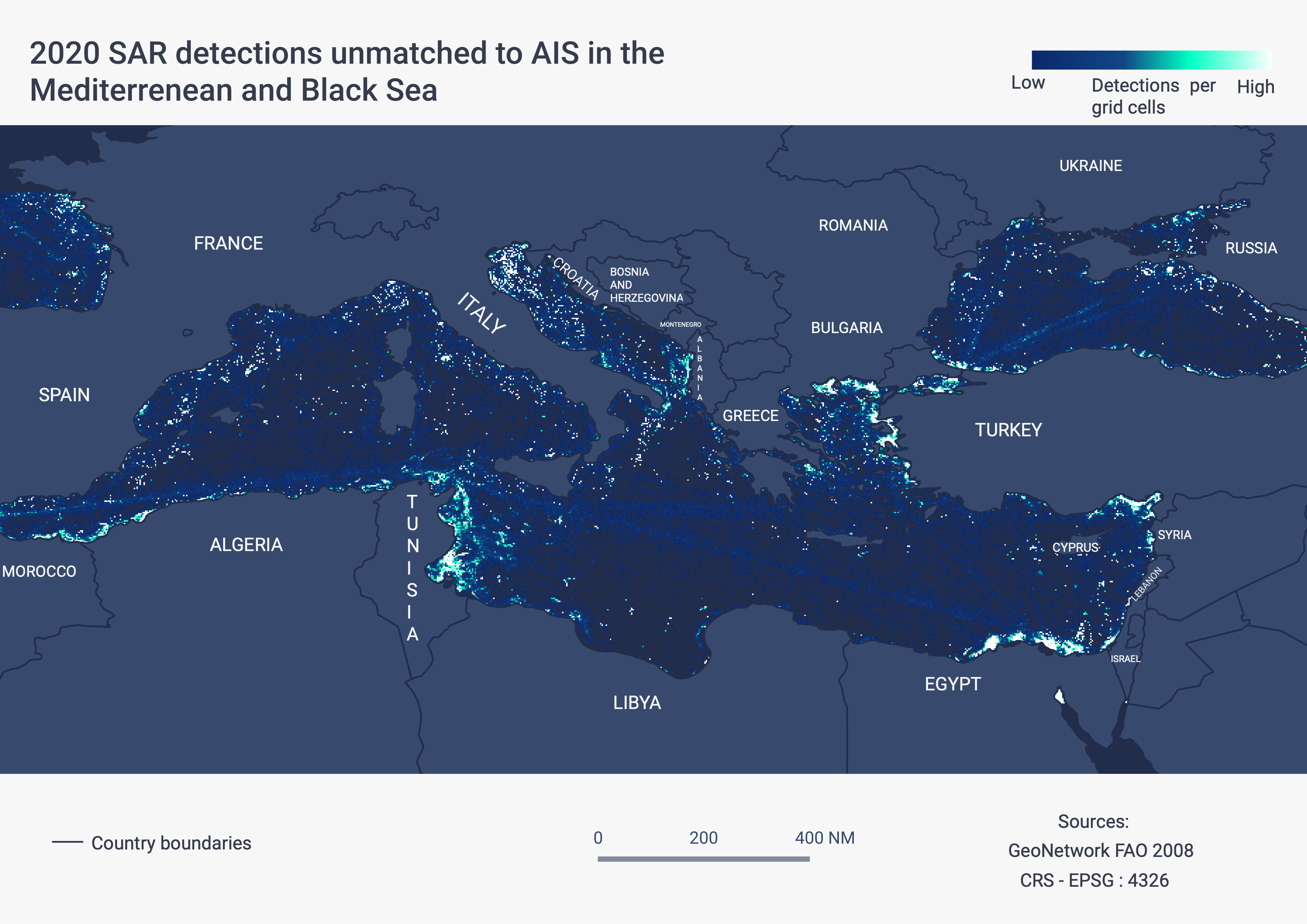
Figure 2. Vessels detected in Sentinel-1 that are not matched to AIS in the Mediterranean and Black Sea. Most of these are vessels that aren’t broadcasting AIS, while some are operating in areas of low AIS reception.
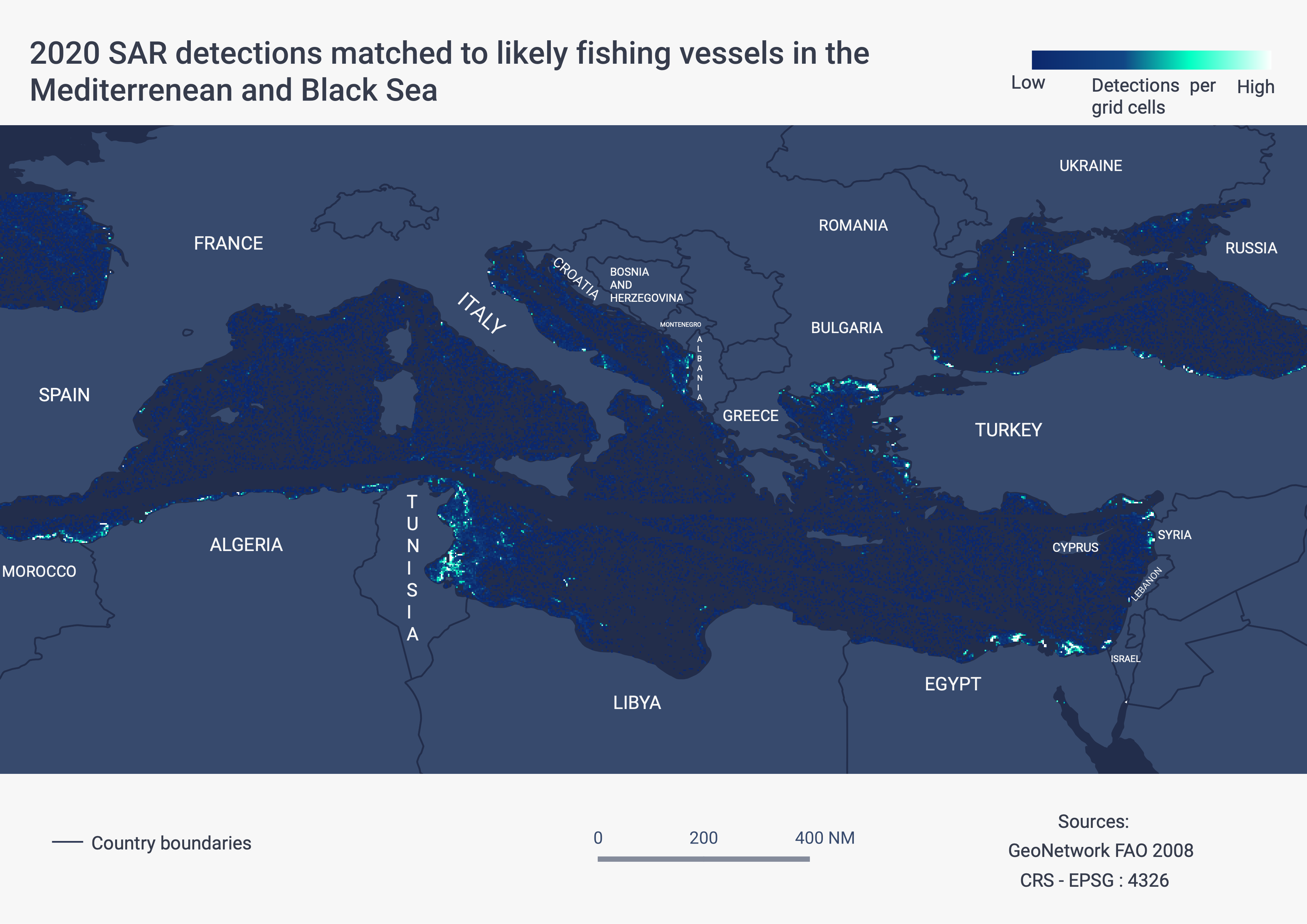
Figure 3. Vessels detected in Sentinel-1 that are not broadcasting AIS (also known as “dark vessels”) in the Mediterranean and Black Sea, after removing vessels detected in the shipping lanes. The unmatched vessels outside of shipping lanes are more likely to be fishing vessels, and this map shows where there is significant fishing activity by vessels without AIS.
Transparency in a whole new light
Radar data can help create a more accurate picture of the presence and behavior of vessels, and help close the net on illicit fishing activities. It can see fishing activity that might otherwise go undetected in areas where there is limited tracking information. Fisheries authorities can use this information to improve monitoring, surveillance and control – to plan patrols and inspections, for example. However, the use of radar data is resource intensive – needing a lot of investment from trained analysts, so it is not yet widely deployed. Because of the Sentinel-1 system, we have a large amount of high quality, publicly available SAR data on the Mediterranean and Black Sea, but this isn’t the case for all fishing areas. And while radar can help us detect the presence of fishing vessels, it doesn’t tell us the vessel’s name, its flag State or the fishing gear it’s using.
Ultimately, while radar can be a useful part of the toolbox, vessel tracking is the most cost-effective way to promote transparency and compliance with fisheries regulations. The long term, transformational solution lies in transparency, and the smart and equitable application of open data and technology. Countries that embrace transparency by publishing vessel registration and tracking data will change the opaque environment in which IUU fishing is able to thrive, and will spearhead action to advance sustainable, legal, and ethical global fisheries in the Mediterranean and Black Sea.
Luca Marsaglia analyses fishing activity in the Mediterranean and Courtney Farthing manages international affairs at Global Fishing Watch.