ⓒ Ben Dilley
Three-quarters of fish stocks in the Mediterranean are overfished, threatening the region’s unique biodiversity and the communities that have relied on its marine resources for generations.
Marine protected areas (MPAs) and other conservation measures are essential in enabling ecosystems and fish stocks to recover, and over the last 10 years, there has been a significant increase in the coverage of protections across the Mediterranean Sea. These include more than 350 areas where bottom trawling is banned. But illegal fishing continues in many of these designated zones, undermining their recovery.
We teamed up with members of the Med Sea Alliance, a coalition of nonprofit organizations working toward the conservation of the Mediterranean Sea, to launch an online atlas—an interactive platform that maps places in the Mediterranean where bottom trawling is banned and helps investigate potential illegal activity in these areas.
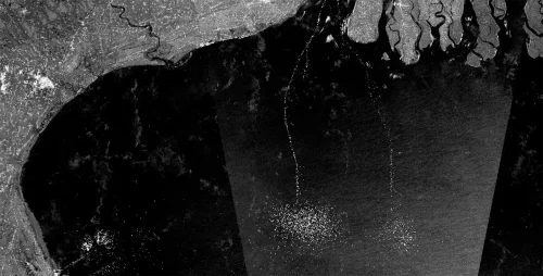
Used by government, academia and civil society alike, the Atlas reveals the extent of illegal bottom trawling in the Mediterranean. A 2021 analysis of vessel behavior—conducted by Global Fishing Watch and based on automatic identification system (AIS) data—documented presumed bottom trawling by 305 different vessels in 35 closed areas between January 2020 and December 2021, adding up to 9,518 days of apparent illegal fishing. This comes on top of 169 confirmed cases of illegal fishing between 2018 and 2020, according to research by MedReAct, one of the Alliance partners. And it’s likely these cases are only the tip of the iceberg, since many vessels—particularly those in the south and eastern Mediterranean Sea—do not transmit on AIS.
But our work in the Mediterranean doesn’t end with the Alliance.
Mapping the footprint of fishing activities is difficult when vessel tracking data doesn’t exist—and monitoring compliance is just as challenging. To address this, we generated a new vessel detection dataset that provides the first estimate of fishing for the entire Mediterranean basin. In October 2023, these innovative efforts were recognized by the General Fisheries Commission for the Mediterranean when we received the prestigious MedFish4Ever award—a spotlight moment for the use of remote sensing data in illuminating fishing activity.
In the coming years, along with our partners in the Med Sea Alliance, we hope to see countries in the Mediterranean investigate and take action against illegal trawling so they can properly protect the marine environment on which they depend. We want to see an effective vessel monitoring system put in place to track the movements of all fishing boats, as well as mandatory use of AIS for all larger vessels.
“Illegal fishing in protected areas undermines national and regional management measures of fish stocks, threatens the livelihoods of fishers who follow the rules and damages marine conservation efforts.”
Aniol Esteban,Med Sea Alliance Steering Committee member