This article was originally published by SkyTruth on May 31, 2023.
In late February, as the world marked the one-year anniversary of the war in Ukraine—the impetus for U.S. and NATO allies to impose new price caps on Russian crude and refined oil products—four tankers broadcast elaborate false tracks in the western Black Sea, our analysis finds. Their real locations were hundreds of miles away.
Since the imposing of sanctions, several investigations have documented the emergence of a “shadow fleet,” including a newly published New York Times article. This assortment of older tankers with unclear owners now carries crude from Russian ports to new buyers in Asia, predominantly in China, India, and Turkey. Many of the concerns around this fleet focus on the safety risks posed by aging tankers, which often lack industry standard inspections and insurance.
However, analyses by SkyTruth and Global Fishing Watch demonstrate that some vessel operators are also broadcasting false positions through automatic identification system (AIS) signals, a global vessel tracking system originally designed for collision avoidance but now also used for vessel monitoring by regulators.
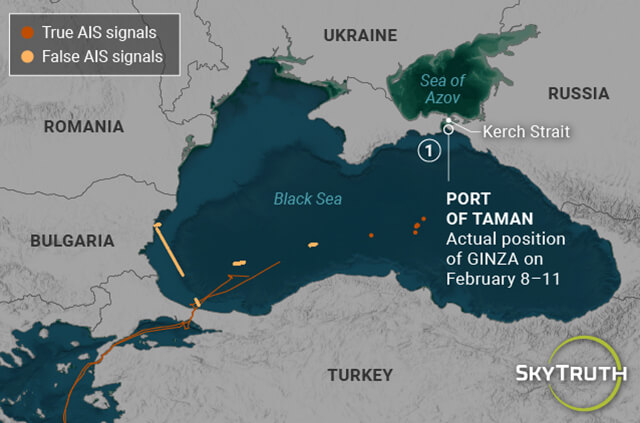
We find strong evidence that between Jan. and May 2023 four tankers—GINZA, TIVY GOLD, KATSUYAMA, and LOURA B—broadcast false positions in the Black Sea, likely to evade detection by monitoring authorities as they entered Russian ports. (One of these ports, Taman, experienced explosions on May 3, reportedly the result of a drone attack.) A combination of satellite imagery and data from the tankers’ AIS reveals that while the tankers were broadcasting positions in the western Black Sea near the coasts of Bulgaria and Romania, sometimes for weeks, their true positions were near the Kerch Strait, 400 miles to the northeast.
These findings come on the heels of a report from December, which identified a Russian-flagged oil tanker—KAPITAN SCHEMILKIN—producing false broadcasts: the first detection of a Russian-flagged tanker sending false AIS signals.
How We Find False Broadcasts Automatically
The detections stem from Global Fishing Watch’s project to comprehensively detect and classify false AIS position data for all vessel traffic worldwide. As part of this work, we have developed several tools for automatically flagging false positions.
One such tool is the automated correlation of vessel detections from Sentinel-1 (S1) synthetic aperture radar (SAR) imagery with AIS. From this correlation we can detect a set of relatively large vessels (more than 80 meters in length), which S1 repeatedly fails to detect at the locations indicated by the vessel’s own AIS broadcast. Investigating these vessels has revealed a number of interesting examples where vessel operators appear to be deliberately broadcasting a false track to mislead regulators, who use AIS to monitor their activities.
Our new analysis correlating AIS tracking data and satellite imagery flagged the AIS positions from the four tankers as false. But what was the real location of the tankers—and what were they up to—while pretending to be hundreds of miles west?
Here we present the available evidence from AIS reception and satellite imagery that allowed us to start unraveling the deceptive tracking data broadcast by each tanker.
Evidence for Data Falsification
After the AIS broadcasts of the tankers were initially flagged as false in our system—as a result of not appearing where indicated on satellite radar imagery—we were able to further confirm the false positions based on the locations of terrestrial receiving antennas. Characteristic repeating patterns in the AIS positions provided additional evidence of falsification.
1. The tankers did not appear at their broadcast locations on satellite imagery.
Sentinel-1 satellite radar imagery is acquired regularly over European waters by the European Space Agency (ESA). This imagery is cloud-penetrating and very effective in detecting metal objects on the water. Vessel features—other than approximate dimensions—can’t be determined with this moderate resolution SAR mode; however, it can cover a wide area of the ocean and identify the precise locations of vessels and offshore infrastructure.
We have developed an image processing pipeline to extract these detected vessel locations and automatically correlate them with AIS broadcasts from the same time and location. Most large ships like tankers broadcast their positions continuously via AIS, which causes their AIS positions to align with a bright spot on the radar imagery. This makes it possible to identify which vessel was detected, as well as where there are groups of vessels not broadcasting AIS (these vessels are often called the “dark fleet”). From this automated correlation of AIS and vessel locations from imagery, we can determine instances where AIS clearly indicates that a vessel should be present but does not appear on the imagery.
All four of the tankers were found to be missing from S1 imagery after entering the Black Sea, often repeatedly over several weeks. For instance, the TIVY GOLD was not detected in eleven S1 scenes that intersected with the vessel’s AIS broadcast from Feb. 18–March 15, 2023, and from March 25–April 1, 2023. The tanker was detected normally before, after, and between these date ranges. When S1 fails to detect a vessel that should be present in a given location, this allows us to identify and confirm particular false segments within the vessel’s AIS track.
Because all of the tankers we tracked were relatively large vessels (around 180 meters in length), there was no ambiguity as to whether they would be detected by this mode of SAR imagery. The fact that these vessels were missing from a number of consecutive S1 scenes caused our model to clearly flag the AIS position broadcasts as false.
2. The positions of the tankers were received by terrestrial antennas hundreds of miles from their purported locations and beyond possible reception range.
Once we began investigating this set of tankers, we discovered a clear anomaly in the AIS reception data. AIS positions broadcast by ships can be picked up by nearby vessels, orbiting satellites, and shore-based receiving antennas. Particularly in high traffic areas, such as European coastal waters, we rely on terrestrial antennas; in these busy locations the high number of messages causes interference for satellite reception. Although the reception range of AIS receiving antennas varies according to height and configuration, 99% of messages received are within 50 nautical miles of an antenna; usually, average reception range is quite a bit less than that.
So, when we noticed the broadcast positions of GINZA and TIVY GOLD—apparently in the western Black Sea—were getting picked up by a receiver 400 miles to the northeast in the Kerch strait, we knew their broadcast positions couldn’t be real. Similarly, the LOURA B—while broadcasting positions purporting to be in the western Black Sea—was picked up by a receiving antenna in Novorossiysk, a Russian Black Sea port southeast of the Kerch Strait.
Identifying the receiving antennas also allowed us to narrow down the real locations of the tankers to a few docks and anchorage sites within the antennas’ coverage areas. In the case of GINZA, this allowed us to locate the vessel at dock using Planet’s high-resolution SkySat imagery. Unfortunately, in late March the Kerch Strait receiving antenna ceased operating for unknown reasons. Perhaps due to this outage, we could not identify the antenna receiving the false positions broadcast by the KATSUYAMA.
3. The tankers showed repetitive movement patterns not characteristic of real vessel movement.
There was quite a bit of individual variation in the false tracks broadcast by different vessels. However, all showed patterns of movement that would be very unlikely or impossible for a real vessel: repeated identical transits segments; near instantaneous jumps over long distances; and anchorage positions that don’t show the normal variation resulting from vessel drift. Closely examining these AIS data patterns allowed us to establish the precise start and end points of false track segments.
Four Tankers show a common pattern of false AIS broadcasts
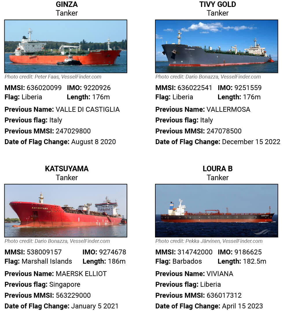
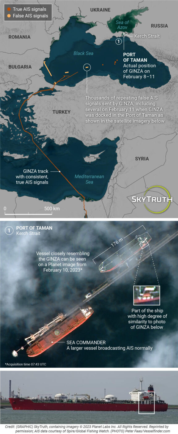
GINZA 176-meter Liberian-flagged tanker
On Jan. 18, 2023, the tanker GINZA transited through the Bosphorus Strait into the Black Sea. That same day anomalies began to appear in the vessel’s AIS tracking data, which continued for the next month and a half. These included false, disjointed track segments purporting to show the vessel either north of the Turkish coast or along the coast of Bulgaria, as well as a number of impossible and seemingly random point jumps to locations around Europe and the South Atlantic. The point jumps themselves are not particularly significant. They may be related to the vessel’s track falsification or even to interference in GPS signals documented in the Black Sea. However, the lengthy false track segments suggest a clear intention by the vessel operators to hide the tanker’s true activity.
From Jan. 18–March 5, 2023, the tanker broadcast more than 12,000 false AIS positions. While it was not possible to account for the vessel’s true activity over this full period, we could see that false AIS positions were being picked up by an onshore receiving antenna in Kerch, approximately 400 miles to the east. (The location of the receiving antenna is publicly accessible on MarineTraffic.) Based on the limited reception distance, we could narrow down the GINZA’s true location to a few anchorages and docks near the Kerch Strait. Using satellite imagery from Planet, we found a non-AIS broadcasting vessel closely resembling the GINZA at the Taman dock between Feb. 9–11.
The Taman terminal where the GINZA was located is used to export oil products from Russia and Kazakhstan. Therefore, we initially assumed that GINZA was likely heading to Taman to load oil. However, a map of the port indicates that the GINZA docked at a location exclusively used to export foodstuffs—and its precise berth position was for exporting sunflower seed oil.
This last detail is intriguing, given reports by the BBC of Ukrainian sunflower seed crops being seized or forcibly acquired at below-market prices by Russian occupiers. There is even a specific allegation that sunflower seed oil is being transported through Crimea and across the Kerch Strait bridge, a route that would bring it directly to Taman. However, the product loaded by GINZA in Taman remains unconfirmed.
On March 5 the GINZA resumed broadcasting real AIS positions in the southern Black Sea as it waited to transit back through the Bosphorus. The tanker then continued through the Mediterranean and Suez Canal, eventually going to China where it docked near the city of Taixing from April 10–15. The tanker has since returned to the Black Sea where it is currently broadcasting Taman as its destination.
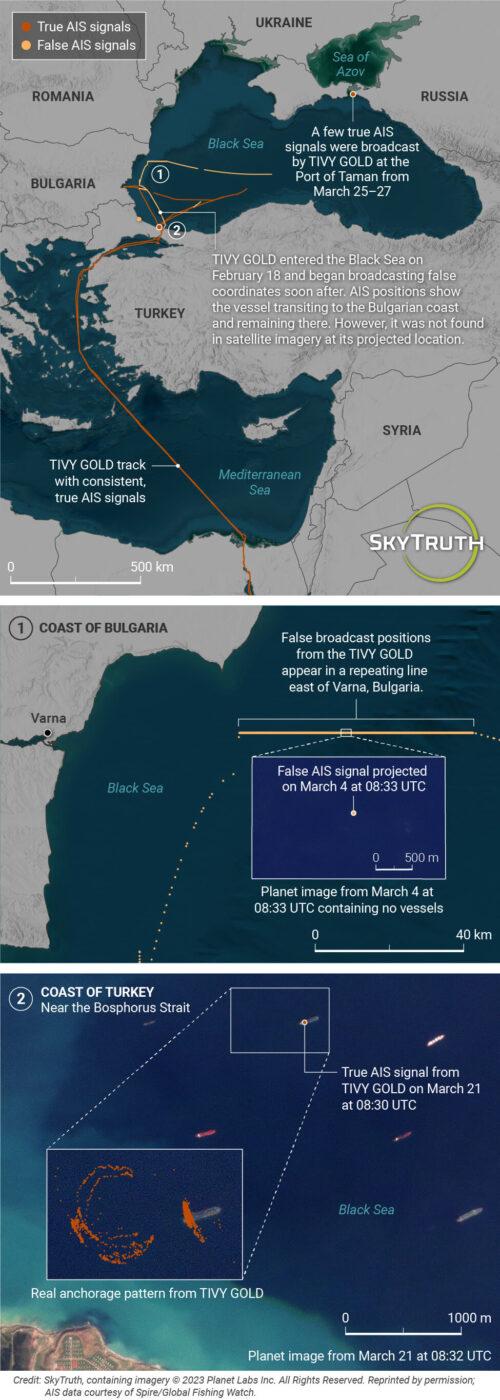
TIVY GOLD 176-meter Liberian-flagged tanker
The TIVY GOLD entered the Black Sea on Feb. 18, 2023. After initially showing a course for Taman, it began broadcasting a false track toward the Bulgarian coast. From Feb. 18–April 6 the tanker broadcast a bewildering array of false and real AIS track segments. Similar to the GINZA, false positions broadcast in the western Black Sea were picked up by an AIS receiving antenna in Kerch, confirming that the TIVY GOLD was somewhere in the vicinity.
Strikingly, on March 25 the vessel’s track suddenly jumps from a line of false AIS positions near Burgas, Bulgaria, to a location 400 miles to the northeast—the TIVY GOLD’s real position as it pulled up to the Taman dock.
It’s unknown what might have prompted the vessel operator to suddenly stop its false broadcasts near the Bulgarian coast. Perhaps a lapse in the ship’s spoofing software or a directive from Taman port authorities forced the ship to revert to real AIS signaling. From March 25–27, AIS positions show the TIVY GOLD going to Berth 5 of the grain dock, which according to the EISA shipping agency website is designated specifically for loading sunflower seed oil. This particular designation for Berth 5 was present on the shipping agency website on May 25, 2022, according to Internet Archive’s Wayback Machine. That information has since been removed from the EISA site.
On March 27 AIS shows the TIVY GOLD leaving the Taman dock, then immediately jumping 400 miles southwest to the previous line of false positions near Bulgaria. Eventually the tanker resumes broadcasting real AIS positions and transits back through the Bosphorus on April 9. The TIVY GOLD eventually made its way back to the Chinese coast, where it docked near Taizhou (Yong An Terminal, Berth 3) from May 16–17, only six miles from where the GINZA had docked on April 10.
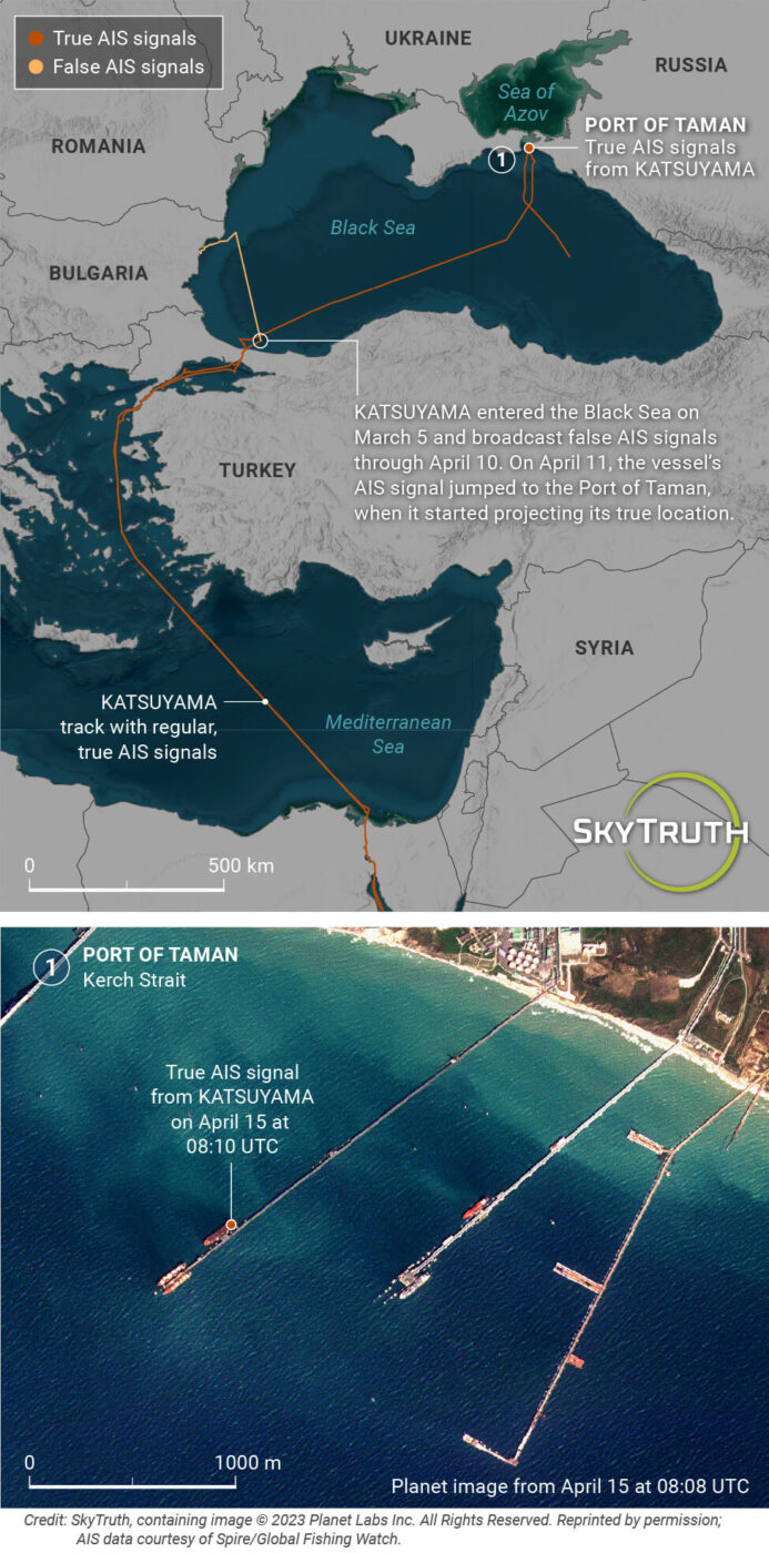
KATSUYAMA 186-meter Marshall Islands-flagged tanker
The KATSUYAMA entered the Black Sea on March 5, 2023. After initially plotting a course toward the eastern end of the Black Sea, the tanker appeared to make a sharp turn westward toward the coast of Bulgaria. However, the positions showing this sudden turn and all subsequent positions broadcast through April 10 were false. Positions during this period appear to show the tanker transiting close to the Bulgarian coast before heading to an anchorage. But satellite imagery confirms no vessel was present at the locations indicated by AIS.
Unfortunately, we were not able to identify a terrestrial AIS receiver picking up the KATSUYAMA’s positions during more than a month of false position broadcasts. Identifying the receiver would have allowed us to pin down the vessel’s real location, as we did with GINZA and TIVY GOLD in Taman. A possible explanation is that the Kerch receiver went offline around March 23—if the KATSUYAMA had continued east to one of the anchorage sites nearby, it might not have been picked up by terrestrial AIS.
On April 11 the KATSUYAMA’s AIS position jumped almost 500 miles east, where the vessel broadcast a real track transiting toward Taman. At the time of the real track transmission, the tanker seemed to be on a course originating from Turkey’s northeast coast. This is the only clue we have as to KATSUYAMA’s true whereabouts during the preceding month.
Once the KATSUYAMA reached Taman, the tanker went to the precise location previously visited by the GINZA and TIVY GOLD: Berth 5 of the grain dock. It remained there until April 15, seen clearly on Planet satellite imagery.
The KATSUYAMA continued to broadcast real AIS positions as it transited out of the Black Sea and to the port of Kandla in India’s western state of Gujarat. Port records from Kandla confirm that the tanker delivered a cargo of 34,500 metric tons of sunflower seed oil on May 5.
Thus, the latest pickup and delivery of the KATSUYAMA was quite clear as confirmed by real AIS positions and port records. The lingering question: What activity led KATSUYAMA to broadcast false AIS positions for more than a month prior to heading toward Taman?
LOURA B 183-meter Barbados-flagged tanker
The LOURA B entered the Black Sea on April 25. After an initial course heading northeast, it began broadcasting false AIS positions showing the vessel going directly north, toward the coast of Bulgaria and Romania. False position broadcasts continued through May 6, many showing the vessel in an apparent anchorage position 40 miles off the coast of Romania. Closer inspection showed all of the positions falling into a small rectangle at a location where no ship was visible on satellite imagery.
During this period the tanker’s false positions were picked up by an onshore AIS receiving antenna in the Russian port of Novorossiysk 400 miles east. The antenna’s limited reception range allowed us to confirm that the vessel’s real location was somewhere nearby. While we were unable to locate the tanker at dock, Novorossiysk is a major terminal for Russian oil export, making it likely the LOURA B went there to pick up a cargo of fuel. On May 6 the vessel resumed broadcasting real AIS positions, which showed the vessel leaving the Black Sea.
The LOURA B had an interesting history before this trip. The vessel was reflagged and renamed very recently (April 10, 2023) in the port of Tripoli, Lebanon. Operating with its previous name VIVIANA, the then-Liberian-flagged tanker had been carrying fuel under the terms of a 2022 UN truce, which authorized specific tankers to enter the previously blockaded port of Hudaydah, Yemen.
The tanker’s 2022 track showed repeated trips between Yemen and the Persian Gulf, presumably the source of the fuel they were delivering. Since leaving the Black Sea, LOURA B has since returned to Hudaydah, where the tanker may be again delivering fuel, this time likely sourced from Novorossiysk.
False AIS threatens the enforcement of international regulations
We can’t be sure of the motivation the operators of these four vessels had for falsifying their data. However, it demonstrates a significant new challenge to regulators attempting to track sources of cargo.
These incidents in the Black Sea are not isolated, but rather part of an alarming increase in AIS data falsification—particularly within the global tanker fleet—over the past few years. The increase may be driven by the proliferation of AIS transmitters with built-in spoofing modes, which allow operators to easily inject false tracks into their broadcasts.
Looking beyond the Black Sea we also have observed other groups of tankers broadcasting false locations. In particular, these broadcasts are hiding entries into Venezuela and Iran and are likely intended to avoid the consequences of international sanctions on exports from these countries.
Fortunately, as demonstrated by our analysis, the technical tools needed to systematically detect false AIS tracks are now well developed and can be implemented at a global scale.
However, deceptive position broadcasts will likely continue until flag states and coastal nations allowing port access explicitly mandate that vessels must broadcast real locations via AIS. Such regulations would safeguard the integrity of the AIS tracking system. It also would strengthen the safety of maritime operations overall—critically important in an increasingly busy ocean. Further, it would help ensure that bad actors are not able to access port facilities or claim false origins for the cargo they deliver.
Bjorn Bergman is a data analyst for SkyTruth and Global Fishing Watch.