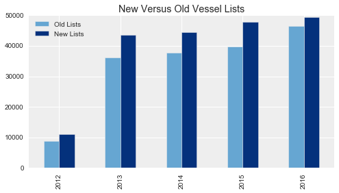
Since our launch in September, we have added 25,000 more fishing vessels to our database. Our new Beta release 2.0 now includes 60,000 fishing vessels.
Although the number of fishing boats using AIS and the number of satellites receiving their signals have been steadily rising around the world, the vast majority of our gains have come from refinements to our analytical methods. The fishing detection algorithm has improved, and we’ve been able to identify more fishing vessels from the data we have.
AIS data is inherently messy, so it takes a lot of work to ensure we are including the right vessel signals in our data platform. We only include fishing vessels that have a statistically high confidence rate for fishing. In our first release of Global Fishing Watch, we only included vessels that broadcast their identity as fishing vessels 100 percent of the time, and for which we had 1,000 or more AIS position messages in a given year.
We identify vessels by their unique Marine Mobile Service Identity (MMSI) number, which is included in their AIS messages. The number of position signals received from an MMSI is an important indicator for us. If there are too few signals from a given identification number, it is likely to be noise rather than a real vessel. But determining what “too few” means took some analyses. It turns out, we receive fewer than 1,000 positions a year from a lot of fishing vessels. By setting our cutoff point too high, we were missing about half of all likely fishing vessels.
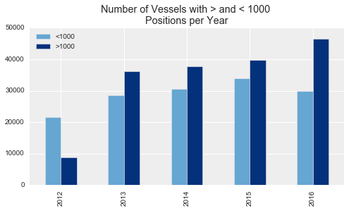
As important as the number of signals is, we found the activity of the vessel to be even more important. Many fishing vessels that broadcast a lot of position signals are actually just sitting in port all year. So we’ve shifted our criteria to account for these analyses.
We’ve reduced the necessary number of position points to 500 and set a requirement for the points to be “active”–that is, position signals indicating a speed greater than 0.1 knots.(We’ve chosen 500 now because our work showed that vessels with only a few hundred positions contribute very little to the total effort and are extremely difficult to analyze.) With these new criteria, we were able to add a few thousand boats per year to our vessel list.
We also found that our criteria were too strict when it came to the identity signals vessels broadcast. Vessel captains set their AIS manually, which means mistakes sometimes occur in the numbers they key in. In such cases, a fishing vessel may errantly identify itself as a tug or a tanker. So, we’re now including vessels that identify as fishing vessels 99 percent of the time, adding another few hundred vessels per year.
With these refinements to our database, Global Fishing Watch Beta 2.0 now includes 60,000 fishing vessels and captures roughly 95 percent of the fishing activity in the AIS data.
Our work is nowhere near done, however. We continue to analyze the data for a deeper understanding. We know, for instance, that some MMSI numbers are used by more than one vessel, meaning sometimes the data indicates one vessel when there are actually multiple vessels. On the other hand, some vessels use more than one MMSI, making it look as if there are multiple vessels when there is only one. Further investigation will help us sift through this skewed data and better match these individual vessels to their positions and tracks.
We are also continually analyzing the data from different angles as well, characterizing errant AIS gaps, distinguishing vessels by type and expanding our understanding of what AIS has to tell us.
[Lists of MMSI numbers and code used to create chart shown here is available on the data site version of this post.]
