Sustainability Through Transparency
Advancing ocean governance relies on better monitoring of human activity at sea
Overview
Covering more than two-thirds of the Earth’s surface, the ocean provides essential nutrition to billions of people and sustains a global economy that is valued in excess of $1 trillion. Home to huge reservoirs of biodiversity, the ocean connects us through commerce, policy, heritage and community.
But the health of our ocean is facing unprecedented threats from both human activity and a changing climate, making management of its resources all the more difficult and urgent. And while the majority of the ocean is yet to be explored—making it the least observed part of our planet—few places are untouched by human activity. This lack of oversight allows unscrupulous behavior to thrive. To make matters worse, illegal, unreported and unregulated (IUU) fishing, which accounts for up to 1 in every 5 fish sold, threatens existing sustainability efforts and undermines legitimate fishing operations.
Despite the need to tackle growing threats, most ocean managers and conservationists are operating in the dark. The true scale of human activity at sea and its cumulative impact are difficult to gauge, preventing the effective management of maritime activities and hindering decision makers from taking preemptive action to avoid irreparable damage to our ocean’s health.
Downloads
Fact sheet
Related Experts

Chief Program Officer

Director, Research and Innovation

Director, Product Development
Technology for good
Advances in big data and technology are rapidly transforming our ability to generate new insights and make information both public and visible. Global Fishing Watch seeks to use this knowledge to help advance ocean governance and enable the fair and sustainable use of marine resources. By creating and publicly sharing map visualizations, data and analysis tools, Global Fishing Watch aims to enable scientific research and revolutionize the way the ocean is managed.
Using cutting-edge technology, Global Fishing Watch generates knowledge about the ocean and turns big data into actionable information. That information is shared publicly, and for free, to accelerate science and drive fairer, smarter policies and practices that reward good behavior and protect biodiversity, fisheries and livelihoods. We aim to monitor and visualize the impact of ocean-going vessels, both industrial and small-scale, that are responsible for the vast majority of the global seafood catch. By promoting international cooperation and harnessing political will, our work seeks to utilize transparency of ocean data to enable a new era of ocean governance.
Our Work
The ocean is vast, yet few places are free from human activity. This makes managing its various resources—and ensuring their sustainability—difficult to do. But Global Fishing Watch is changing that.
Using satellite technology and artificial intelligence, we built the first global map to visualize and publicly track the industrial fishing fleet. Anyone with an internet connection can access the online platform, providing them with a wealth of scientific information and enabling them to monitor ocean areas and analyze vessel activity in near real time. With the recent explosion in ocean data and emergence of new technologies, we are able to revolutionize how we understand and manage the marine environment.
By unlocking this digital ecosystem and putting information freely into the hands of people that need it and the decision makers who can act on it, we hope to create a comprehensive picture of what is taking place across two-thirds of the planet’s surface, illuminating what has been hidden and possibly illegal, until now.
Transparency toward greater ocean governance
Transparency of information is crucial for good stewardship of the ocean, driving accountability for ocean resources that sustain livelihoods, food security, and biodiversity. But without a global picture of our activity at sea, we cannot truly understand the impact that humans have on life below water. This lack of visibility is compounded by a patchwork of management regulations, fostering an environment where illegal activity can thrive.
At Global Fishing Watch, we believe that improved governance of the ocean can only happen through increased transparency of information, from vessel identification and registries to fishing authorizations, compliance history and the public tracking of vessel activity. Even the publication of rules and regulations surrounding specific maritime zones is important when it comes to ensuring better management of the ocean.
Global Fishing Watch is committed to bringing countries from around the globe into our transparency program to advance responsible fisheries management.
Impact on the Water: Patrolling the Pacific
In 2021, the U.S. Coast Guard undertook a two-month patrol in support of Operation North Pacific Guard, an annual high seas fisheries law enforcement operation designed to detect and deter IUU fishing. Global Fishing Watch provided data and analysis on suspicious vessel activity for the operation which uncovered 450 shark fins and 32 potential violations. The collaboration built on the inaugural support we provided in 2019 which saw a threefold increase in vessel boardings and an eightfold increase in identified violations compared to 2018.

Making waves around the world
The ocean knows no boundaries, making the work at Global Fishing Watch worldwide by nature. Our regional teams are working across the globe—Africa, Asia, Europe, Latin America and the Pacific—to provide a more comprehensive picture of what is taking place throughout jurisdictional waters and the high seas. Global Fishing Watch partners with governments to enhance:
Vessel tracking: We work with governments to publish their vessel data on our map, strengthening monitoring efforts. Thanks to the commitment of governments, proprietary vessel tracking data has been shared on our public map by an increasing number of progressive countries from around the world, creating a more complete and connected picture of global fishing activity.
Monitoring and analysis: Through big data processing and machine learning, our teams of experts on the ground are demonstrating the value of open data and helping surface some of the most significant gaps in fisheries monitoring by providing governments with innovative tools, intelligence and analysis.

Sustainability and management: Global Fishing Watch works with a variety of partners to support sustainability efforts across fisheries and strengthen research to improve management practices. By engaging various governments, including those that are integral to processes in international fisheries management, we seek to deliver tracking and analysis tools that help inform flag States about their fleet’s activities.
Capacity development: We present innovative and emerging technologies to various countries with the goal of harnessing their potential application in fisheries management. By assessing the needs of our partners and those using our tools, we hope to understand the existing and desired capacity of others to use the kinds of technology-based products that Global Fishing Watch specializes in developing.
Research and innovation
Machine learning and satellite technologies are transforming the way we manage the ocean, but taking advantage of these technologies requires effective partnerships and an interdisciplinary team. Global Fishing Watch collaborates with leading scientific institutions to produce new open-source datasets and analyses to better understand the most critical challenges facing our ocean. These partnerships have helped create key technologies to monitor human activities at sea. Drawing on remote sensing and vessel positioning data, we aim to publish impactful research on illegal fishing, forced labor, transshipment, vessel traffic and other human activity in the marine world—all while empowering others to use our data to help achieve more sustainable ocean governance.
To date, our collaborations have led to the publications of more than 40 scientific papers, including several in Science and Nature that have led to the creation of new marine protected areas, illuminated dark fleets that were previously undetected, and changed the way we understand and protect the ocean.
"Global Fishing Watch is a godsend to ocean conservation. It is the only remote vessel tracking system that is global and publicly available. This is the beginning of the end of illegal fishing."
Dr. Enric Sala, National Geographic Society
Creating insights through tools and data
We help local partners and governments get the most of our ocean data by unlocking insights on how to better manage fisheries and safeguard marine biodiversity. Our internationally recognized map is serving as a new mission control for fisheries management, from coastal countries whose ports are flooded with illegal fishing to driving smarter management of marine protected areas around the world. We believe that building the capacity of others will change daily practices and policies for better, more durable outcomes.
The map
Only a fraction of the global ocean is regulated by governments, making the management of global commercial fisheries complex. Fish stocks straddle jurisdictional boundaries, and baseline data on stock health is often inconsistent or not available at all. Further complications occur as the enforcement of existing management measures presents even greater challenges. Vessels operate far from land, out of sight and reach of authorities. And traditional monitoring and surveillance methods, including at-sea patrol, are costly and often inefficient. Due to the sheer size of the ocean and the dynamic nature of fishing, knowing where to look can be overwhelming, even where enforcement resources are available. But ocean governance starts long before enforcement.
The Global Fishing Watch map is the first open-access, free online platform for visualization and analysis of vessel-based human activity at sea. Anyone with an internet connection can access the map to monitor global activity of about 80,000 fishing vessels, which make up about 20 percent of the industrial fleet.
Powered by satellite technology and machine learning, the map merges multiple types of vessel tracking data to provide a view of global human activity at sea. It analyzes data collected from vessels and transmitted through satellite and terrestrial receivers.
This includes fishing activity, encounters between vessels, nighttime vessel detection, synthetic aperture radar and vessel presence. Algorithms are applied to the tracking data to determine what is happening on the water and where suspicious activities at sea are occuring. The map also allows anyone to upload and overlay their own data, download reports of activity from custom areas, and save and share workspaces. Free and easy-to-use features offer unprecedented opportunities to increase transparency across the world’s ocean and support the fair and sustainable use of marine resources.
Marine manager portal
Marine protected areas (MPA) play a significant role in addressing threats facing the ocean. They are essential for the recovery and protection of biodiversity, as well as the productivity and resilience throughout marine environments. Design and management of MPAs are often hampered by inadequate information to support decision-making. Failure to get data from those who produce it to those who use it often leads to lost opportunities to inform management decisions.
To help address this, Global Fishing Watch and Dona Bertarelli partnered to develop Global Fishing Watch Marine Manager, an open-access technology portal that helps improve insight into marine protected areas.
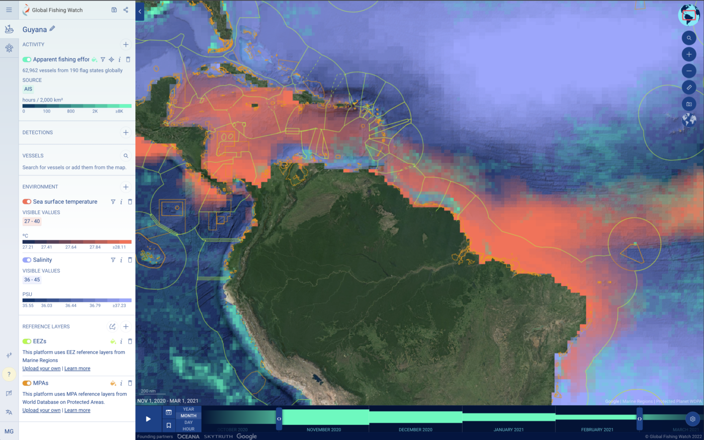
Free to the public and supported by Google Earth Engine, the portal provides near real-time, dynamic, and interactive data on ocean conditions, biology and human-use activity to support marine spatial planning, scientific research, and the design and management of MPAs. The portal allows individuals to rapidly collate and analyze a wide range of vessel and oceanographic data in a single platform—all at no cost to them—helping them complete their objectives in a fraction of the time it used to take. Marine Manager includes pioneering capabilities, such as the ability to overlay vessel activity and position information with environmental datasets like sea surface temperatures and salinity levels, and to monitor both individual vessels and groups of vessels that are engaged in commercial fishing and other activities, such as tourism, shipping and oil drilling.
Marine Manager is a shining example of how revolutionary technology and accessible, science-based data can make a vital contribution to improving oversight of human activity in and around marine protected areas and help bolster management of ocean resources.
API portal
When it comes to protecting the ocean, inequitable access to information often leads to lost opportunities in decision-making and innovation—especially in under-resourced countries. The global community continues to fall short in efforts to conserve and sustainably use the ocean and its marine resources.
That is why Global Fishing Watch has set forth on a mission to enhance the transparency of fishing vessel data and help governments address threats to marine resources, including IUU fishing.
To protect our ocean more effectively and efficiently, as well as facilitate a shared investment with other like-minded groups, we created a technology portal that provides application programming interfaces, or APIs, to integrate, share, access and scale our data with the global ocean community. The portal provides a new way for partners and stakeholders to access dynamic datasets that are used in all our tools and incorporate the data directly into a user’s own system, platform or research.
Empowering stakeholders can only be achieved through continual evolution of our technology, including the integration of new data sources and the enhancement of data formats, visualizations and accessibility. We make a curated set of data available to others through our data download portal, helping support the research community and equip stakeholders with underlying data directly from our map.
By providing streamlined access to information on current fishing vessel activity, identity and history, we are helping create solutions for a resilient, sustainable ocean and transforming the way human impacts are researched and monitored across the world’s ocean.
Carrier vessel portal
Transshipment, or the transfer of fish from one vessel to another, is a vital part of the global commercial fishing industry. But the monitoring and control of this activity is often met with many challenges. Taking place far out at sea, beyond the reach of authorities, transshipment can present unscrupulous operators with the opportunity to manipulate or omit data pertaining to their fishing practices, fostering conditions that enable IUU fishing to take place, as well as other maritime crimes.
To improve the understanding and management of transshipment, Global Fishing Watch partnered with The Pew Charitable Trusts to develop the carrier vessel portal, a global, public database that harnesses transparency to bring greater monitoring and analysis of this activity to those who need it. The two organizations established the portal to help policymakers and fisheries managers better comprehend the activities of carrier vessels that take on catch from commercial fishing vessels and deliver it to ports worldwide for processing. The portal provides a valuable tool for managers that seek to verify transshipment activities, which can help reduce opportunities for unauthorized transfers of fish products and also identify when such activities are not being adequately reported.
“There is real value in open data when it comes to monitoring the ocean. By making our fishing activity visible on the Global Fishing Watch map, the Republic of the Marshall Islands is helping demonstrate compliance. We hope the data-led insights complement already existing monitoring, control and surveillance tools to validate what is being reported by flag States and strengthen the way fisheries are managed.”
Glen Joseph, director of the Marshall Islands Marine Resources Authority
Impact Through Partnership: Joint Analytical Cell
Established in 2022 by the International Monitoring, Control and Surveillance Network, Global Fishing Watch and TM-Tracking, the Joint Analytical Cell harnesses innovative technology and the complementary expertise of its collaborating organizations to enhance fisheries management and combat illegal, unreported and unregulated fishing. By bringing together various stakeholders to build key insights and strengthen capacity, the Joint Analytical Cell seeks to promote collaboration, make data and tools readily available, and produce effective and intelligence-led enforcement responses. Working alongside a coalition of diverse organizations, this initiative aims to create credible and equitable cooperation from around the globe and present integrated solutions to deliver change on the water.
Impact Through Research: Illuminating the Dark
In a 2020 study, we combined multiple satellite technologies to reveal hundreds of vessels illegally fishing in North Korean waters. Originating from China, these vessels poached an estimated half-a-billion dollars’ worth of Pacific flying squid from the ocean. The findings from this research attracted international attention and the results were dramatic: illegal fishing in the region has dropped by more than 75 percent.
Illegal fishing in the region has dropped by more than
0%
A healthy and productive ocean
A resilient ocean offers a multitude of solutions to the various challenges we face when it comes to food and environmental security, as well as the increasing threats associated with climate change. But to reap the benefits, we have to prioritize the protection of marine resources and implement mechanisms to ensure that our activities at sea are effectively monitored and controlled and that fishing is carried out both legally and sustainably.
By collaborating with governments, businesses, nongovernmental organizations and research institutes, Global Fishing Watch remains committed to creating and sharing insights to radically improve transparency and create a sustainable future for our ocean and all those who depend on it.