
Detailed Apparent Fishing Activity
Overview
Global Fishing Watch’s flagship dataset tracks apparent fishing activity, which is based on automatic identification system (AIS) transmissions and vessel monitoring systems (VMS) data shared by partner countries.
AIS data include a vessel’s identity, location, speed, direction and more, collected through a global network of satellite and terrestrial receivers. Global Fishing Watch processes billions of AIS messages daily, and uses vessel movement patterns and registry information to identify vessels that are likely to be fishing. Using machine learning algorithms, Global Fishing Watch classifies vessel and gear types and infers fishing activity from features such as changes in speed and direction, relying on research by Kroodsma and Turner.
To produce a global dataset of apparent fishing activity predictions, our general fishing model must operate across diverse fisheries with varying definitions of what constitutes fishing. As a result, the training data used to build the model, and the predicted fishing activity, encompass a range of fishing-related behaviors, including searching, setting gear, hauling and gear soaking.
The Global Fishing Watch platform displays these estimates as “apparent fishing activity” and “apparent fishing events”. These outputs are model-based estimates, not confirmed records of fishing. The following sections explain how the datasets can be used and detail their limitations and caveats.
Use cases
The Global Fishing Watch dataset supports a range of applications for fisheries authorities, civil society, researchers and media, including:
- Monitor apparent fishing activity in near-real time: Track vessel activity and apparent fishing hours across global waters, exclusive economic zones (EEZs), and marine protected areas (MPAs).
- Support enforcement and compliance: Identify suspicious vessel behavior, such as potential fishing near MPAs, to help authorities prioritize patrols and investigations.
- Analyze trends over time: Examine historical apparent fishing activity in relation to seasonal patterns, policy interventions and environmental events.
- Inform fisheries management and spatial planning: Combine AIS- and VMS-derived apparent fishing activity with ecological and jurisdictional data to support zoning decisions, policy development and ecosystem-based management.
- Increase transparency and accountability: Use publicly available AIS and VMS analyses to promote open and inclusive ocean governance and support market-based approaches to responsible sourcing.
AIS limitations
- Not all vessels carry AIS transponders: AIS is mainly used by vessels longer than 24 meters operating far from shore. Many small-scale or artisanal vessels do not carry AIS devices and are omitted from the AIS-based apparent fishing activity layer.
- Inconsistent transmission: AIS broadcasts are more frequent and detectable with the Class A devices common on larger vessels. Class B devices, used by smaller vessels, have weaker signals and are received less reliably, especially by satellite. Gaps in AIS transmissions can affect estimates of fishing activity, potentially leading to overestimates or underestimates.
- Signal interference and reception gaps: In high-traffic areas, overlapping AIS signals can interfere, making individual transmissions more difficult to detect by satellite.
- Deliberate disabling or falsification: AIS can be turned off or spoofed, leading to false locations or shared identities.
- Data quality and update lag: Not all providers capture or share complete AIS datasets. Terrestrial stations may log messages less frequently, and satellite data coverage is uneven.
- Changes over time: Fluctuations in apparent activity can reflect shifting AIS usage, changing access to terrestrial stations or dynamic AIS (a specific data component of the AIS that represents a vessel’s real-time, continuously changing movement and operational status), or reception quality rather than actual changes in fishing behavior. When conducting a long-term study on fishing activity trends using this data, contact Global Fishing Watch for guidance on interpretation.
VMS limitations
- Gaps in source data: VMS data may occasionally be missing for some time ranges. Global Fishing Watch’s data pipeline automatically reprocesses the last four days, so outages within that window usually resolve automatically. However, VMS feeds can temporarily fail or shut down, requiring manual review.
- Low-frequency polling rates: VMS position reports are generated at predetermined intervals, known as polling rates, which can be infrequent (often occurring every hour or two). As a result, short-duration fishing activities occurring between successive position reports are more difficult to detect.
- Tampering: Although VMS tampering can sometimes be detected, it can result in transmission gaps or false position reports.
Caveats
- Interpreting apparent fishing activity: The general fishing model estimates fishing-related activity and reflects a range of behaviors — such as searching for fishing grounds or preparing gear — rather than solely gear deployment or retrieval. These estimates do not necessarily indicate that gear was deployed or retrieved at a specific location. They should not be interpreted as precise records of gear setting or hauling.
- False positives: AIS- and VMS-based models identify apparent fishing activity based on movement patterns. They may classify positions as fishing even when a vessel is not fishing, such as when it slows down or changes direction. Global Fishing Watch continues to work to reduce false positives in future data releases.
- Bias in vessel identification and gear classification: Misclassifications in vessel or gear type may occur due to inconsistent or incomplete registry data. Algorithms can also struggle to categorize vessels that use multiple gears or share a Maritime Mobile Service Identity (MMSI) number. When MMSI recycling occurs, the vessel classification model may misclassify vessel and gear types, thereby biasing apparent fishing activity estimates.
- Apparent fishing events vs. apparent fishing activity: Apparent fishing events group consecutive fishing positions into summarized events for easier visualization. These events apply filters based on time, distance and vessel behavior, which can exclude some positions. Consequently, apparent fishing events and apparent fishing activity may differ, especially when fishing activity is spread across long distances or time gaps.
General fishing model: How it works
Historically, Global Fishing Watch has used a convolutional neural network AI model to estimate apparent fishing activity. Details of the original model are described in the supplementary materials of the 2018 Science paper, “Tracking the Global Footprint of Fisheries.”
In 2026, the convolutional neural network was replaced with a transformer-based model. Together with new training labels, this update produces more accurate predictions at the track level.
Fishing model pipeline
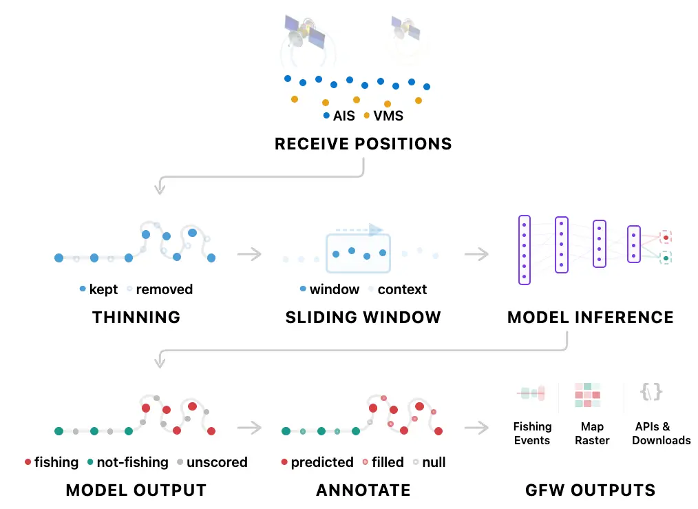
The following steps are used to produce estimates of apparent fishing:
- The transformer-based model estimates activity across a segment — a consistent set of positions — of a vessel track.
- The model then samples a reduced set of satellite positions within those track segments, selecting one position every 10 minutes. This creates a consistent selection of central positions for each 10-minute chunk.
- The model applies a sliding three-day prediction window, retaining predictions for the middle day while using days one and three for context. It shifts by one day on each pass.
- The model produces an inference, or classification score, for each category at each thinned position.
- In a post-processing annotation step, Global Fishing Watch propagates predictions back to raw positions. If two thinned positions are 12 hours or less apart with the same predicted category, intermediate positions inherit that category; otherwise, they are classified as “null.”
- Apparent fishing is estimated for every vessel position, and that estimate is summarized into apparent fishing events and overall activity.
Model performance
Conventional metrics — precision, recall and F1 score — assess model performance over a test dataset, also known as holdout dataset, of more than 400 labeled tracks. The model achieves F1 scores across gear types ranging from 0.78 to 0.94 (vessel-weighted mean of approximately 0.89), performing best for trawlers and drifting longlines and lowest for fixed gear and set gillnets. Global Fishing Watch assessed the performance of the updated general fishing model against two known historical issues: in-port fishing and transit fishing. The updated model reduces in-port fishing by 64 percent (within a 100-meter buffer zone for all of 2024) and decreases transit-position fishing by 46 percent.
Systemic bias
- Resolution constraints: As noted in the AIS and VMS limitations, determining vessel activity is challenging when broadcast frequency resolution is low, both for human annotators and machine learning models. In some cases, short-duration fishing behavior may not be captured.
- Geographic and gear coverage gaps: Training and testing labels are not fully representative of global fishing activity due to constraints in labeling resources and localized domain expertise.
- Model accuracy: The fishing model is often more accurate for gear types and regions supported by robust labels or logbooks and less accurate in locations with limited data. Standard machine learning performance metrics — such as precision, recall and F1 score — cannot be computed for fisheries without labeled data. Global Fishing Watch continues to dedicate resources toward improving the diversity and geographic representation of training labels.
Statistical bias
- Model limitations:
- Machine learning models cannot correctly classify every observation. Prediction errors may occur when the available data do not provide enough information to distinguish fishing from other vessel activity in regions or fleets lacking training labels.
- The new general fishing model is far more precise, but there are instances of false negatives — not estimating real fishing — in specific gear types. This change is mainly evident for:
- “All seines,” “Fixed gear,” “Pots and traps,” “Set gillnets,” “Set longlines” and “trollers.”
- Limited accuracy when estimating fishing activity close to shore in shallow water.
Squid jigger predictions
Apparent fishing activity for squid jiggers is estimated using a simple rule-based approach (or heuristic) rather than the general fishing model. Squid jigging can be observed through loitering movement patterns at night, often involving operations with bright lights while stationary, based on research by Seto and colleagues. The heuristic algorithm classifies positions as fishing if a squid jigger is more than 10 nautical miles from shore with a mean speed below 1.5 knots at night for more than four hours.
Longline predictions prototype
To enable fisheries managers and the seafood industry to verify longline vessel compliance with seabird bycatch mitigation measures, we developed a prototype insight that highlights possible setting and hauling events. This insight is intended to assist in checking non-compliance by highlighting vessels with a higher risk.
To meet those requirements, we developed:
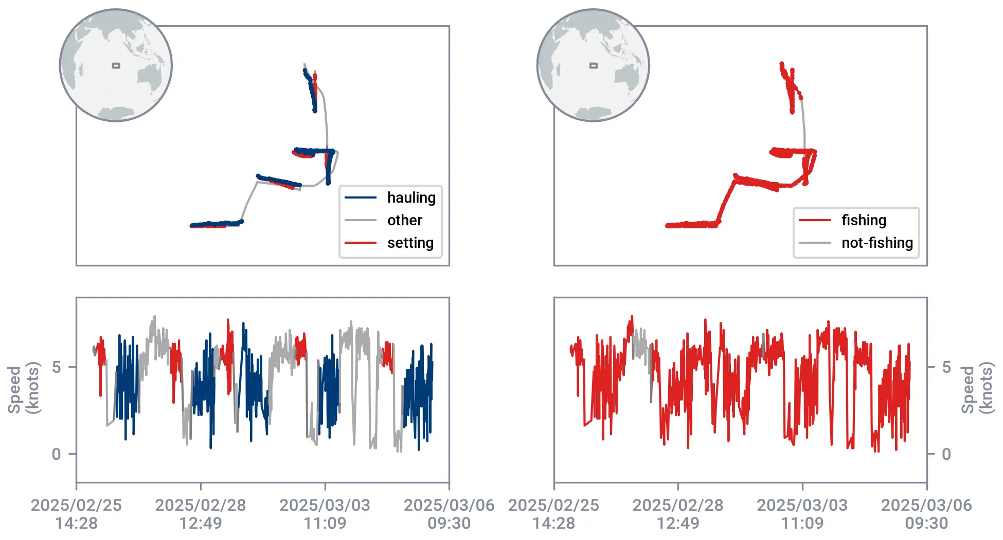
- A new drifting longline fishing model built using the same model architecture as the new general fishing model, but trained on a different subset of drifting longline labels to identify more fine-grained behaviors, including setting and hauling.
- Insights adapted from the general fishing events model, based on new drifting longline fishing model predictions.
Drifting longline fishing model and general fishing model
- Predictions from the general fishing model and the drifting longline model are independent.
- The general fishing model has been optimized to predict fishing-related activities across different gear types, thus capturing a wide range of fishing activity.
- The drifting longline model is trained exclusively on drifting longline vessels to predict specific behaviors like setting and hauling, based on research by Kroodsma and colleagues.
- As such, the general fishing model might predict fishing activity in sections of tracks that the drifting longline interprets as non-fishing or vice versa.
- For this reason, in our products for drifting longlines, we include both fishing events from the general fishing model and night-setting information from the drifting longline model.
Building the drifting longline fishing events insights
The insights are based on the general fishing model’s fishing events process and were adapted to use drifting longline model predictions. The changes introduced to generate drifting longline fishing events include:
- Threshold updates. The filters used to generate fishing events from raw positions were adjusted as follows:
- The default filters we use to generate the general fishing model’s fishing events were developed to cover all gear types, not drifting longlines specifically. As a result, legitimate drifting longline events were filtered out.
- New thresholds were added to be more inclusive, such as increasing the maximum threshold for average speed.
- Event definitions. An apparent drifting longline fishing event is defined as one where:
- Fishing positions appear consecutively and are separated by less than 60 kilometers or eight hours; and
- Fishing positions within one hour or two kilometers of another fishing event are grouped into a single event.
- Exclusion filters. The following criteria are applied to exclude unlikely fishing activity:
- Events shorter than 20 minutes in duration;
- Events comprising a single fishing position;
- Events covering a distance of less than 0.5 kilometers; or
- Abnormally fast-moving events with an average vessel speed of 14 knots or faster.
- Set timing and lighting metadata. Drifting longline events include information about when sets occurred with respect to:
- Nautical dawn and dusk in UTC decimal hours (0 to 24); and
- Day-night summary categories, such as “Entirely day,” “Mostly day” and “Day and night.”
- Applicability. Insights apply only to vessels classified as drifting longliners.
Events generated from the general fishing model are independent and might differ from the drifting longline model.
Caveats and known issues of the longline model
- Training and testing labels are not fully representative of global fishing activity due to limits in labeling resources and local expert knowledge. The fishing model may be more accurate for gears and locations where labels or logbooks are available and less accurate for gears and regions with fewer or with no labels.
- This dataset is a prototype intended for testing and user feedback and it is subject to errors or inaccuracies over time. This insight is not intended to serve as proof of non-compliance, but rather as a tool to assist in identifying non-compliance by highlighting higher-risk vessels. Known issues in the current drifting longline insight prototype include:
- Nearshore false negatives: False negatives can occur, particularly near shore.
- Timing precision: Inaccuracies may exist in event start and end times. For instance, the model may predict that a set starts earlier or ends later than visual track examination suggests.
- Review: Due to possible variations in predicted set start and end times, users should review the set category by examining vessel movement along the track alongside predicted start and end times and nautical dawn and dusk times.
Citation
Depending on the tool used to download the data, apply the following citation formats:
- Map, public APIs or packages: Global Fishing Watch. 2026, updated daily. Apparent Fishing Activity, version [X], [Time range]. Data set accessed YYYY-MM-DD at https://globalfishingwatch.org/
- Data Download PortalGlobal Fishing Watch. 2026. Apparent Fishing Activity, static version [X], [Time range]. Data set accessed YYYY-MM-DD at https://globalfishingwatch.org/
License
Global Fishing Watch data is licensed for non-commercial use only. The site and the services are provided for non-commercial use only in accordance with the CC BY-NC 4.0 license. If you would like to use the Site and/or the Services for commercial purposes, please contact us at [email protected].
Access our data
Data on apparent fishing activity are available through several Global Fishing Watch tools:
- Global Fishing Watch map: Explore apparent fishing activity information across ocean areas, exclusive economic zones and marine protected areas.
- APIs and packages: Access apparent fishing activity data programmatically through the Global Fishing Watch Vessels API, as well as the gfwr package for R users and the Global Fishing Watch Python package. This is the same data available in the Map.
- Data Download Portal: Download a complete static dataset and supporting documentation, including apparent fishing activity. Unlike the continuously updated map and APIs, data available through the portal represents periodic static snapshots.
Each platform offers access to different components of the apparent fishing activity dataset. To determine which tool best fits your needs, refer to our data availability guide.