Satellite radar imagery is lighting up our view of previously unseen fishing patterns around the world
Last week, we announced the winners of the xView3 contest to use satellite radar imagery and artificial intelligence to reveal vessels at sea. This week, we give you a gist of what this technology can do when deployed at scale.
We are using radar to “see” every large vessel on the ocean—including the countless ones that don’t publicly broadcast their locations, and are “dark” in monitoring systems.
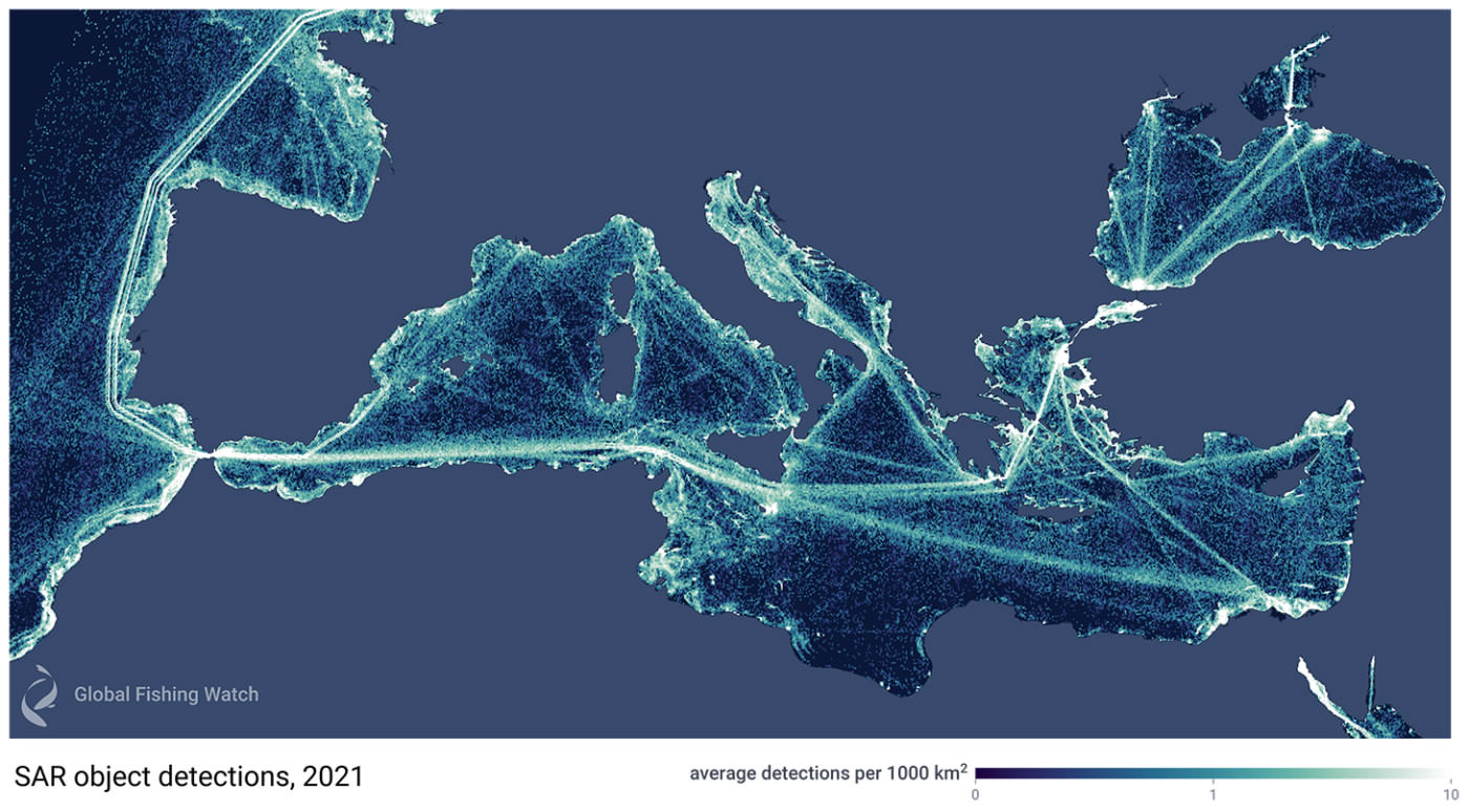
To accomplish this goal, our automated cloud pipeline crunches petabytes of satellite radar imagery, processing about 400 scenes per day, and extracting more than 20,000 daily detections. These images are then run through a sophisticated matching system to pair them with known vessel locations based on the automatic identification system, or AIS. We are also developing a model to differentiate which of these vessels are fishing vessels, similar to the models in xView3, and we are excited about the results—it will soon be possible to map the dark fishing fleet globally. Shown above is a subset of a global dataset of one year’s worth of detections, showing off all vessel traffic in the Mediterranean Sea.
We are excited to share a preliminary view of this radar data in our marine manager portal, where you can view radar detections for a full year across the Mediterranean Sea. Shown is a subset of a global database of almost nine million detections extracted from 140,000 radar images taken by the European Space Agency’s Sentinel-1 satellites in 2021, a task made possible by Global Fishing Watch’s big data pipelines and our unique visualization technology.
A new age of mapping possibilities
Why is this so exciting? Because we can now see the incredible amount of fishing along the north coast of Africa that was hidden from view before—and this is just the beginning. Zoom into the coastal waters of Africa and filter the map for vessels that are not matched to AIS, and you’ll see a great amount of activity. Visit the map workspace in our marine manager portal.
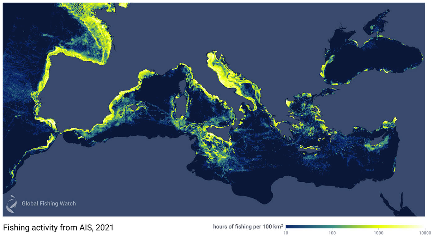
Until now, much of our “seeing” of human activities at sea has relied on information from AIS transponders, such as those that the EU requires on all fishing vessels over 15 meters in length. To illustrate how much more we are now able to detect with the addition of satellite radar imagery, the figure below shows the fishing activity we are able to see if we only use AIS data for 2021. With this technique alone, the waters off of North Africa look practically empty and the picture is incomplete.
By comparison, the next figure shows the density of vessel traffic across the Mediterranean and nearby waters for 2021 when we use SAR and machine learning to detect and classify vessels—technology that we can now automate and scale globally to reveal unseen fishing patterns around the world.
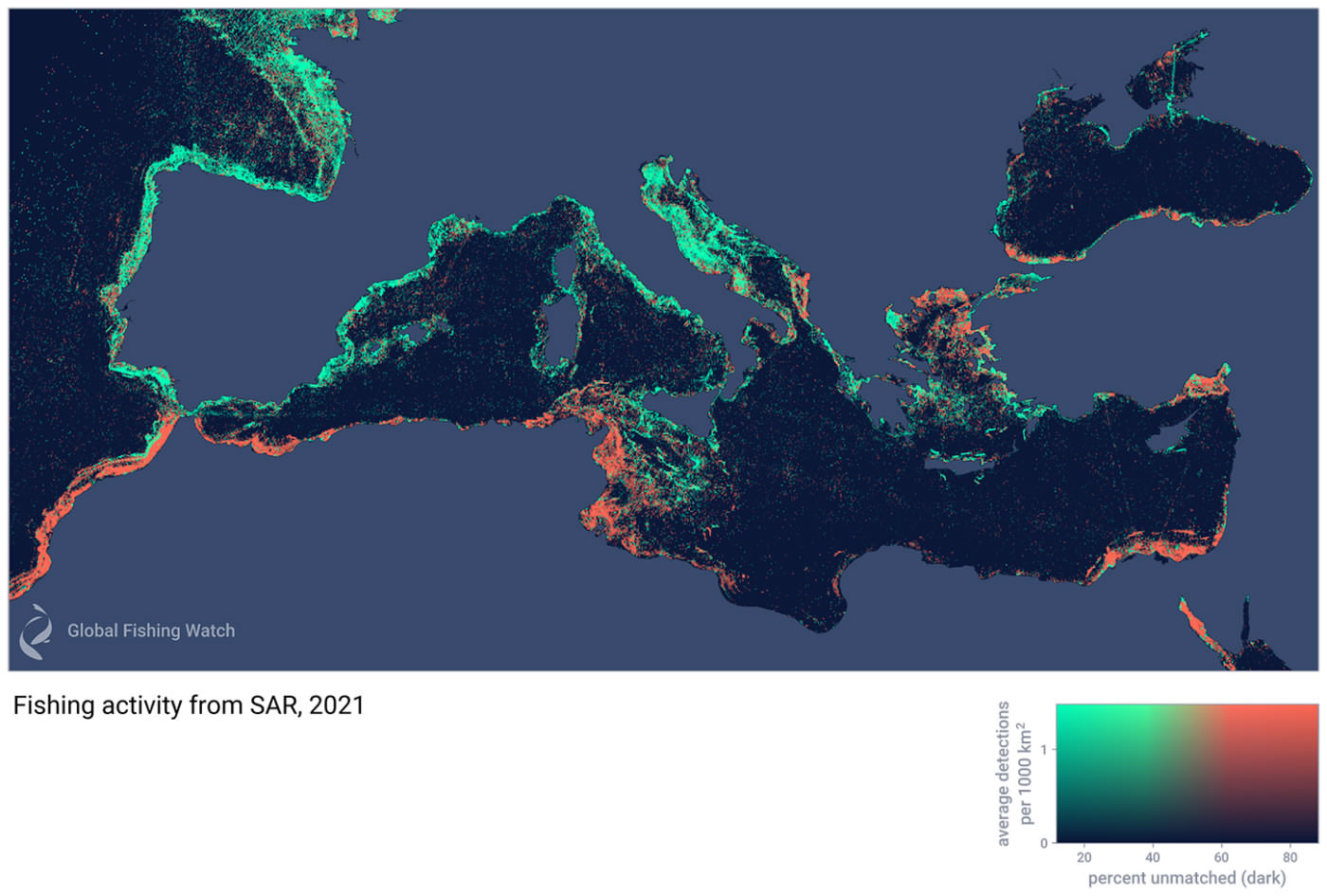
Suddenly, North Africa lights up with intense activity by vessels that are not broadcasting AIS but are now visible with our radar detection technology. What’s more, our machine learning models say these are likely fishing vessels.
We are highlighting the Mediterranean in this initial release of data because radar imagery will be of immense help in this region over the next few years. Our work in these waters has included three reports that analyze fishing activity inside fisheries restricted areas that protect vulnerable marine ecosystem habitat. These reports draw on radar imagery data to identify potential vessels not broadcasting AIS. We have also launched a dedicated Mediterranean and Black Sea marine manager portal that includes fisheries restricted areas and cold water corals locations.
We should note that although vessels that do not broadcast their position are sometimes linked to unlawful activity—as we found in a study of rampant illegal fishing in North Korea—“dark fishing” usually isn’t illegal. Many of these vessels not broadcasting their position are actually not required to do so. For example, countries along the coast of Africa or Albania in the Adriatic Sea don’t have AIS requirements as they are not members of the EU. This lack of information is precisely what has clouded our ability to map out and understand the true footprint of fishing.
A next generation of modeling
To push the boundaries of what is possible with radar imagery, we co-hosted a competition to build better algorithms to detect vessels with this imagery. Working with the U.S. Defense Innovation Unit, and supported by the U.S. Coast Guard, National Oceanic and Atmospheric Administration and the National Maritime Intelligence-Integration Office, we helped conduct the xView3 computer vision challenge to identify dark fishing vessels using satellite radar and machine learning. For this contest, we processed and prepared thousands of images, provided detailed training data by partially drawing on our models, and challenged contestants to build the best possible algorithm.
xView3’s top contestant, BloodAxe, developed a model using complex scans that can estimate the size of a vessel and whether it is a fishing vessel. This model did especially well close to shore, where it can be extremely difficult to differentiate vessels from rocks or human-made structures. The model, now freely available, is something we will be studying in our effort to build a second generation model. The other top algorithms, all open source, are now also available to share and use.
We are entering a new, exciting age in the monitoring of human activity at sea. At Global Fishing Watch, we started our work by tracking vessels that broadcast their GPS positions. With the rise of satellite radar technology and advanced machine learning, we are now transitioning to the ability to see every large vessel at sea. Over the next few months, we will be scaling these models to estimate the true, global footprint of humans on the ocean.
David Kroodsma is director of research and innovation at Global Fishing Watch.