Ask the Expert
Luca Marsaglia
Fisheries analyst, European Union

What is the value of using research-derived datasets in analyses?
Fisheries management is no simple task. The distribution of species, changes in productivity, management boundaries, illegal fishing and corruption are all factors that make oversight and governance of fisheries challenging. And the Mediterranean Sea is no exception. A total of 21 coastal States—spanning nations across Africa, Asia and Europe—border its waters, resulting in a complex geopolitical situation where management of shared resources presents difficulties. This is especially true when information on human activities at sea is not available. But new datasets are emerging all the time to help fill these gaps in knowledge.
Mediterranean waters see heavy industrial use. Over 70 percent of fish stocks remain harvested above biologically sustainable levels—and new gas, wind and aquaculture sites are being explored for possible development in the coming years. As a result, several countries in the region have signed on to 30X30—a global initiative committed to protecting 30 percent of marine areas by 2030.
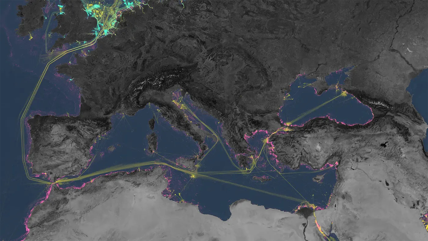
Network of Human Activities on the Mediterranean Sea
Satellite data and AI show a complex network of human activities on the Mediterranean Sea, revealing the development of offshore oil and wind infrastructure, and patterns of vessels engaged in fishing, transport and energy. ⓒ 2023 Global Fishing Watch
Recent improvements to the European Union (EU) regulation around vessel tracking—specifically automatic identification system (AIS) and vessel monitoring systems (VMS)—have led to an increase in public data and fishing activity information across the Mediterranean. However, the footprint of fisheries remains a challenge to map. This is particularly true in some non-EU countries, including countries in North Africa where public vessel tracking data does not exist.
Mapping the spatial footprint of fishing activities allows us to understand the three dimensional space where fishing takes place in the marine environment—a fundamental piece of information for implementing policies to regulate and manage fisheries. Without vessel tracking data to monitor compliance or evaluate the effectiveness of management measures, the enforcement of fisheries restricted areas, marine protected areas and temporal closures proves nearly impossible. It is also vital to have information on the distribution and intensity of regional fishing activities when proposing new spatial or temporal measures. Currently, this information is not available for the majority of Mediterranean waters.
New datasets like the one developed for our vessel and infrastructure detections work, can play a fundamental role in the realm of fisheries and marine ecosystem management—an acknowledgment that was recently made by the General Fisheries Commission for the Mediterranean in recognition of Global Fishing Watch’s work at the MedFish4Ever Awards. The new vessel detection database offers a turning point in management for these areas in the Mediterranean that lack vessel activity data. We are now able to provide the first estimates of fishing footprint for the entire basin.