Furthering innovation and collaboration is at the heart of Global Fishing Watch’s mission to advance responsible stewardship of our oceans through increased transparency.

Our Research Partners program, an interdisciplinary collaboration with some of the world’s leading marine science institutes, strives to improve fisheries management and science via new research and data sharing through our public and freely available platform and data.
Our recent study published in Science was produced with partners at the University of California, Santa Barbara, the National Geographic Society’s Pristine Seas project, SkyTruth, Dalhousie University, Stanford University, and Google, and has produced the first-ever dataset of global fishing activities.
I was really pleased to see that the study was widely welcomed and the findings of the paper broadly recognised. Global Fishing Watch’s algorithm processed 22 billion messages publicly broadcast from vessels’ Automatic Identification System (AIS) positions between 2012 and 2016. An extraordinary feat, and one only made possible thanks to recent advances in computing power, an increase in satellites in orbit, and improved machine learning technology.
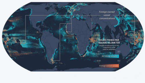
Although the study identified more than 70,000 likely industrial fishing vessels – their size and engine power, what type of fishing they engaged in, and when and where they fished down to the exact hour and square kilometer – this is still less than half of the estimated number of active industrial fishing vessels in the world.
Fishing in unprecedented resolution using unprecedented data
Based on just one year of data, that of 2016, the study reveals that more than 55% of the ocean surface is subject to industrial fishing. By area, fishing’s footprint is now over four times that of agriculture. How the researchers arrived at this calculation is explained here by the paper’s lead author, David Kroodsma.
One of the most interesting findings in our paper is that the ocean is actually much less fished than previously estimated. That does not detract from the fact that about 80% of commercial fish stocks are either fished to capacity or overfished.
Existing datasets had estimated catch in 95% of the area of the ocean. We found, instead, that vast areas of the ocean, such as the Southern Ocean and northern Pacific, are not fished. These areas may offer opportunities for high-impact yet low-cost marine conservation.
AIS offers insight into fishing activity
While AIS – an open broadcast of a ship’s identity and location – is primarily designed as a safety mechanism to avoid collisions at sea, analyzing it can produce a powerful and much needed window into fishing vessel activity.
The fraction of fishing vessels with AIS varies considerably between regions of the ocean. In some regions, such as Europe, it is mandatory. Europe has led the way with the Control Regulation that requires EU fishing vessels to be equipped with AIS transmitters. The regulation also states that “Member States may use AIS data for monitoring and control purposes”.
Many advocates for responsible ocean management believe AIS should be mandated in this way globally. Beyond this, we are also seeing States go public with their Vessel Monitoring System (VMS), designed specifically for fisheries management and previously proprietary.
As an experienced mariner, I advocate that fishing vessels operate with AIS at all times to promote safety of life at sea. I have experienced first hand how hard it can be to detect vessels engaged in fishing especially in heavy seas, poor weather or reduced visibility.
Strengthening and sharing data for greater transparency
We are continually strengthening the data available in our platform, and promoting its responsible use to inform marine stewardship discussion. We recently doubled our AIS data, and through our government and research partners, are including VMS. We delay transmission to our map of sources such as VMS to allow transparency without compromising a vessel’s real-time activity. We can also integrate more recent vessel trackers, such as those provided by Pelagic Data Systems.
Publically available data from Visible Infrared Imaging Radiometer Suite (VIIRS) and Synthetic Aperture Radar will have increasing utility, meaning that even vessels that are not transmitting their position on AIS or VMS can be spotted and their activity taken into account in our estimation of fishing activity.
We are also looking to add new layers of data to ensure fishing activity and ocean science are more interconnected. For example, data on physical oceanography, biodiversity and human stressors, such as coastal population.
Crucially, by making our map and all our data public and freely available, we aim to increase transparency in the commercial fishing industry and improve opportunities for sustainable management and informed decision making.
Finding solutions together
Global fishing activity has long been hard to monitor and, along with patchy regulation and weak enforcement in many parts of the ocean, has greatly contributed to illegal and unreported fishing.
Whether through AIS analysis, or other data, we must exploit all means possible to better understand what is happening in our ocean. And we must strive to do this openly and publicly.
Transparency will drive self-correcting behaviour. Transparent activity and compliant vessels should be rewarded – they should see benefits such as swift port entry, quicker landings in order to allow trusted vessels to get back to sea to continue to fish responsibly.
Non-compliant vessels should be made to bear the cost of the additional resource needed to bring them to justice; where their activity is not clear to port officials they should be delayed in port and inspected; fish should not be landed until its provenance is proven.
It is only by working together that we can hope to combat illegal activity which threatens marine life and the livelihoods of responsible fishers.
Global Fishing Watch is committed to being part of the solution. We’re growing our collaboration with governments, business, NGOs and research institutes to share insights and advance ocean sustainability through increasing transparency.
We invite all ocean advocates to join us in this journey.

