Search results for: What is AIS

User Guide – Portuguese

Guia de Mapas English | Español | Français | Portuguese |中文 Menu Introdução O mapa Global Fishing Watch é a primeira plataforma on-line de acesso aberto para visualização e análise da atividade humana baseada em embarcações no mar. Alimentado por tecnologia de satélite e aprendizado de máquina, o mapa mescla vários tipos de dados de […]

Datasets and Code: Apparent Fishing Effort

Datasets and Code: Apparent Fishing Effort Global Fishing Watch’s flagship dataset is apparent fishing effort based on transmissions broadcast using the automatic identification system (AIS). In 2018, we published the first global assessment of commercial fishing activity in the journal Science. Our research found that fishing is both widespread—occurring throughout approximately 50 percent of the […]

Challenges an opportunities - Global Atlas of AIS - based fishing activity

New global atlas on using advanced technology to monitor fishing activity

Fishing vessels with Automatic Identification Systems (AIS) increasing by 10 to 30 percent each year. 19 November 2019, Rome – A new global atlas – the first-ever of its kind – analyses the opportunities and challenges of using Automatic Identification Systems (AIS) to monitor fishing activity around the globe. AIS is a tracking technology designed […]

Sustainable Fisheries Management Begins with Vessel Tracking

International agreement to track vessels will bring greater accountability, build compliance and help protect fishers Despite being a global, publicly shared resource, there is little transparency about what takes place across the ocean—especially when it comes to fishing on the high seas. Vessel tracking is a key method to understanding this activity, but Global Fishing […]

Whale photo

Whaling off the map

Are whaling vessels that operate without using aids to avoid vessel collision putting the safety of biodiversity and people at risk?   This week the International Whaling Commission (IWC) has convened in Slovenia. The gathering marks the 30th anniversary of the commission’s moratorium on commercial whaling.

Datasets and Code: Vessel Identity

Datasets and Code: Vessel Identity Transparency plays a central role in promoting the sustainability of marine resources and advancing ocean governance. Information that allows us to better understand vessel identity is a fundamental part of transparency. But such information is often fragmented, incomplete or inconsistent across multiple sources, and sometimes it is not publicly available […]

Ask the Expert: Tim Hochberg, Senior machine learning engineer

Ask the Expert Tim Hochberg Senior machine learning engineer How do you match automatic identification system data with satellite imagery to identify publicly tracked vessels? Automatic identification systems, commonly referred to as AIS, transmit a ship’s position and alerts others to its whereabouts. While originally designed as a collision avoidance mechanism, AIS is regularly used […]

Fisheries Transparency in the Mediterranean: Time to Emerge from the Dark

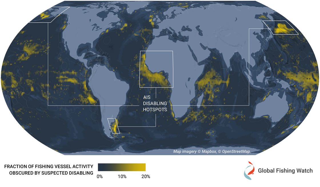
Global Fishing Watch is using radar data to detect fishing vessels hidden from monitoring systems Global Fishing Watch is working to transform fisheries governance by harnessing satellite data to publicly show the movements of fishing vessels. A key data source for detecting apparent global fishing activity is satellite automatic identification system, or AIS—a collision avoidance […]

Scroll to Top

Help us improve the site

Take a quick website survey to help us build a better experience for visitors like you.