Search results for: Fishing Map

How can I interpret night light detections (VIIRS) data in the map?

The VIIRS satellite sensor can identify bright lights at night. This is the same sensor that is used to make the maps of lights at night of the world that you may have seen. In the dark ocean, vessels using bright lights stand out to this sensor and can be tracked. Some forms of fishing, […]

A digital network overlay with interconnected lines and dots covers an ocean scene with boats from the Patagonian toothfish fishery, under a clear sky and setting sun, symbolizing maritime connectivity or communication.

Global Fishing Watch Data Ethics Principles

Our Principles Related expert: Paul Woods and Hannah Linder Data ethics at Global Fishing Watch At Global Fishing Watch, data is fundamental to achieving our vision, driving the need for a robust approach to ethical considerations and decision-making in data stewardship. To address this, we commissioned the Open Data Institute to help us establish data […]

Capacity for Women in the Maritime Sector

Women in Maritime Africa – South Africa and Global Fishing Watch Establish Program to Build Capacity for Women in the Maritime Sector

New initiative aims to equip women with skills for work in monitoring, control and surveillance Women in Maritime Africa, South Africa chapter (WIMA-SA), and Global Fishing Watch (GFW) have joined forces in a partnership that seeks to develop technical skills for women in the maritime sector. The collaboration will establish a training program specifically designed […]

The Global Fishing Watch logo and text appear on a digital, blue, wave-like background with glowing dots, evoking the look of a data visualization of the ocean.

Global Fishing Watch Data Availability

Tool Comparison Table Map APIs R Package Python Package Data Download Visualization capabilities and collaborative workspaces Enables search by area or vessel Allows downloading filtered AIS data in various formats, including GeoTIFF, CSV, and JSON. Centralized API access for developers and technical users (same APIs used by the Map). Supports programmatic access via REST API […]

global fishing map

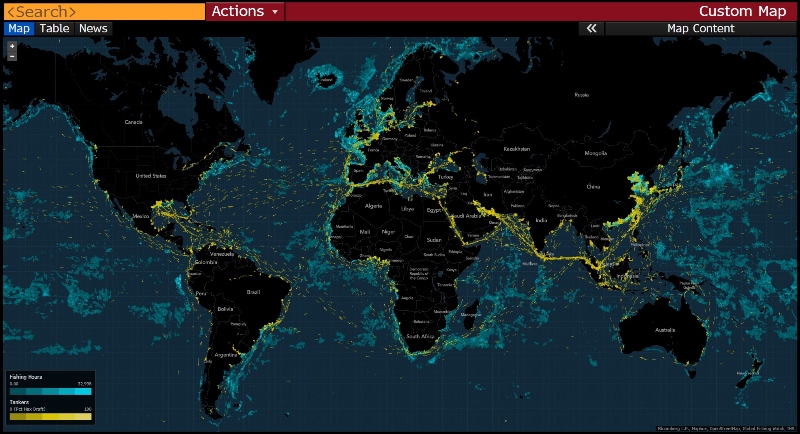
Data on global fishing activity and ocean ecosystems now available on Bloomberg Terminal

 Access to Global Fishing Watch’s data, alongside geospatial tools available on the Terminal, will increase monitoring and protection of ocean ecosystems and communities at risk from overfishing and climate change Oslo, Norway. October 24, 2019. Today at Our Ocean 2019, Bloomberg Philanthropies Chief Executive Officer Patricia E. Harris announced a new initiative between Bloomberg LP and […]

oceana team

How Oceana used Global Fishing Watch data to promote transparency at sea during 2018

With increased transparency, we can see beyond the horizon and address the threats facing our oceans. Global Fishing Watch’s (GFW) mapping platform increases the transparency of commercial fishing activities worldwide, empowering Oceana and others to expose problems that were once out of sight, far from our coasts. Oceana analysts, part of Oceana’s Illegal Fishing and […]

people in room

In Latin America, Training Helps Governments to Discover Suspicious Behavior

Global Fishing Watch reinstates in-person training with partners to strengthen the use of technology in support of responsible ocean management Lack of available information on global and regional fishing activity is one of the biggest challenges when it comes to monitoring the ocean and understanding the true extent of humanity’s impact on the sea.  To […]

Global Fishing Watch welcomes partnership with Papua New Guinea to share vessel tracking data

Momentum builds as a second nation in the Pacific makes critical decision to make fishing activity data accessible and transparent  In a newly established partnership with Global Fishing Watch, Papua New Guinea has committed to sharing vessel tracking data from its Fishing Industry Association on the organization’s public map. Through this agreement, the Pacific island […]

African Nations to Use New Technology in Tightening Port Controls, Fighting Illegal Fishing With Big Data

Pilot project delivers new vessel tracking technology and analysis where limited resources hamper detection and enforcement efforts Dakar, Senegal – Four African nations and a regional fisheries organization are harnessing new technology to strengthen port controls and combat illegal fishing. The international nonprofits, Global Fishing Watch and Trygg Mat Tracking are partnering with Senegal, Ghana, […]

aerial vessel

Illuminating global fishing activity with satellite AIS

This article was produced and first published by our data partner, Spire Global. Transparency in a whole new light In February this year, a Vietnamese ship entered Indonesian waters, likely fished illegally, and then returned to port without consequence. By March, it was back at sea. There were no signs to indicate that the vessel […]

Scroll to Top

Help us improve the site

Take a quick website survey to help us build a better experience for visitors like you.