Global Fishing Watch launches major data upgrade for clearer picture of global fishing activity
Global Fishing Watch launches major data upgrade for clearer picture of global fishing activity
- Published
In latest update, artificial intelligence and cutting-edge infrastructure changes will improve fishing estimates and vessel identification for vast swathes of global ocean data
WASHINGTON, D.C., United States— Global Fishing Watch today launched a major upgrade to the technology powering its global ocean mapping, combining next-generation artificial intelligence with enhanced geographic data to track fishing activity in unprecedented detail. The international nonprofit says the upgrade delivers its most accurate picture yet of human activity at sea, equipping governments, researchers and civil society with clearer data to monitor, protect and manage ocean resources.
The upgrade, available as of Oct. 21, 2026 across Global Fishing Watch’s public map, APIs and downloadable data products, introduces new AI models that improve how Global Fishing Watch distinguishes apparent fishing activity from other vessel movements and identifies different types of vessels at sea.
Covering data spanning from 2012 to the present, the upgrade also provides a more precise view of global fishing activity, reducing instances in which vessels maneuvering near ports, slowing in speed or transiting across the water could be incorrectly identified as actively fishing. In addition, the upgrade also improves Global Fishing Watch’s ability to correctly distinguish fishing vessels from other vessels.
According to Paul Woods, chief innovation officer at Global Fishing Watch, this greater accuracy can have “beneficial real-world consequences.” Governments regularly use Global Fishing Watch data to help monitor fishing fleets and marine protected areas, researchers use it to study fishing activity and its impacts and civil society organizations use it to investigate activity at sea. An improvement in the underlying data means those users can now focus their attention on the activity that matters and make decisions with greater confidence.
“The ocean is vast, dynamic and extraordinarily difficult to monitor. Artificial intelligence allows us to make sense of billions of vessel positions and turn that raw data into a compelling picture of human activity at sea that simply wasn’t possible a decade ago,” said Woods. “This upgrade represents a major leap forward in that capability. The better we become at distinguishing actual fishing behavior from everything else happening at sea, the more useful that information becomes for governments, researchers and ocean stewards making decisions.”
A clearer picture of fishing at sea
The new release represents the first major structural update to Global Fishing Watch’s core AI models for estimating apparent fishing activity and classifying vessels since the organization was established. It incorporates years of research and user feedback to address known discrepancies and improve the accuracy of the data that governments, researchers and other users rely upon.
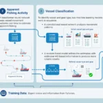
The upgraded fishing model uses over 1000 expert reviewed examples of fishing for model training, new algorithm architecture and updated anchorages and geographic boundaries to more precisely determine whether a vessel is indeed fishing. This allows the system to better distinguish fishing behavior from vessels moving slowly in ports, sitting at anchor or simply transiting.
As a result, users may see lower levels of apparent fishing activity in some places and an overall decrease in global estimates across both automatic identification system, or AIS, data and vessel monitoring system, or VMS, feeds. Hannah Linder, Global Fishing Watch’s data ethics lead and one of the architects behind the data upgrade, notes that this reflects the removal of false positives that the previous model incorrectly identified as fishing.
“When you improve the lens, the picture changes,” said Linder. “The world hasn’t suddenly started fishing less; we’ve developed a better way of distinguishing apparent fishing behavior from the enormous amount of other vessel activity happening at sea. Science advances by continually testing and improving what we know, and our commitment to transparency means making those improvements available to everyone.”
Smarter identification of vessels
The release also upgrades the AI used to identify different types of vessels at sea. By examining vessel movement alongside information broadcast through AIS, the new model can more accurately determine whether a vessel is a fishing vessel, cargo ship, tanker or another vessel type. This improved analysis has allowed thousands of vessels to be more accurately classified between fishing and non-fishing categories. The identification of gear and drifting buoys in the water, previously a longstanding source of false positives for vessels, has also substantially improved.
Against that backdrop, the improvements unveiled with the upgrade also extend beyond AI. Global Fishing Watch has incorporated more than 5,300 new anchorages across 13 countries, improving distance-to-port calculations and eliminating erroneous port visits. A new unified spatial grid standardizes information including distance from shore and from port while a new source of higher-resolution bathymetry improves estimates of ocean depth.
New spatial datasets will also allow users to examine fishing activity alongside updated versions of Global Fishing Watch reference layers, including FAO Major Fishing Areas for Statistical Purposes, General Fisheries Commission for the Mediterranean Fisheries Restricted Areas, and the ProtectedSeas marine protected area database.
Updating the record: transparency through ‘evolving knowledge’
Because the upgraded models have been applied retrospectively to data dating back to 2012, some historical estimates and vessel classifications will change. To help researchers, governments and other users understand those differences, Global Fishing Watch will provide access to both the previous and upgraded datasets for a limited time, allowing users to compare results and assess how the changes affect their analyses.
Users can also easily flag potential issues right within Global Fishing Watch’s built-in reporting tools. That feedback, together with local knowledge from partners around the world, will help inform the continued refinement of its models.
Like any automated system, the upgraded models have limitations. Some vessels and apparent fishing activity may still be misclassified due to model biases or limits in available source data. Global Fishing Watch recommends that its data be used alongside official vessel registries, local intelligence and original tracking information when reaching definitive legal or regulatory conclusions.
“Transparency isn’t about pretending that data never changes. It’s about being open about how it is produced, where its limitations lie and how it improves,” continued Paul Woods. “As our technology gets better, so does our understanding of what is happening at sea. Making that evolving knowledge openly available is fundamental to our mission.”