Tony Long, Global Fishing Watch’s chief executive officer, finds cause for gravity but also hope as we look to the Decade of Ocean Science and a growing consensus that our future—and the course ahead for ocean conservation—should be powered by waves of data, shared and open to all
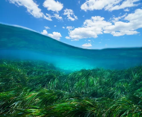
We wish the news were better, but it’s been a year of continuing crisis and less positive resolution than we might have all hoped. The ocean yielded no sign it is less fragile, and nature gave no indication it is less furious. Among the snapshots from the climate emergency—the National Oceanic and Atmospheric Administration (NOAA) declared July the hottest month on earth ever recorded. Important ocean currents that moderate global weather and Europe’s winter, thrown off balance by climate change, showed dangerous signs of weakening. Minderoo Foundation, on World Fisheries Day, published their new research indicating fish populations are faring much worse than we thought; but the striking message was that the data is simply missing to truly understand the state of the fisheries. Strategic trends predicted in decades past seem on the cusp of coming true—such as mass migrations and climate-induced conflict over food and other resources. There’s a feeling we are reaching a tipping point, and terms like “last chance,” are being used more frequently to describe our prospect of reversing the tide.
It’s small wonder that many of us looked for inspiration and guidance in the 2021-2030 United Nations Decade of Ocean Science for Sustainable Development, and the 26th UN Climate Change Conference (COP26) in Glasgow, which Britain’s Prince Charles described as the “last chance saloon” to put the brakes on a climate veering off the rails. Just one of the ways Global Fishing Watch acknowledged this important juncture was by signing the Scientific Call for Ocean-Based Action to Tackle the Climate Crisis, a rally cry to look to the ocean for badly needed solutions and a course forward.
Despite the challenges ahead, there are important signs we are beginning to find our way. The themes of the Ocean Decade yield a striking thread that surfaces repeatedly:
Data—lots of it, coherently integrated and accessible—will help us through the storm.
A number of the endorsed decade actions show increased data sharing and transparency as promising engines for tackling our collective climate problems. The world is coming to agree, for example, that we need better access to comprehensive, accessible oceanographic data in order to understand and address a broad range of issues and their potential social and economic repercussions. In its decade action Promote Seabed 2030 and Ocean Mapping, NOAA captures both its ambition and the argument for a data-driven future, saying, “A full map of the ocean is a crucial starting point for the desired outcomes of the Decade, and failure to produce an adequate map prevents us from globally achieving the ocean we want.”
NASA, too, is on pace with its decade-long mission to advance insights into the ocean’s response to a changing climate through significant investment in satellite ocean color data, and aerosol and cloud data. We need to map, better integrate and share the world’s scattered datasets. There is no longer any question; the explosion in new data and technology can fuel collective efforts to better govern our ocean resources. We are excited to be part of the revolution to unlock innovative ocean data and science and nature-based solutions.
Tools for a data-driven future
Looking back on 2021, we see a busy year for innovation. We launched the Global Fishing Watch Marine Manager portal, founded by philanthropist and ocean advocate Dona Bertarelli and listed as one of the UN endorsed Ocean Decade actions. The marine manager tool draws together the data of many different agencies in a dynamic way to support the design, management and monitoring of increasingly critical marine protected areas (MPAs) and other area-based conservation measures across pilot partner sites in Ascension Islands, Galapagos, Guyana, Niue, Tristan da Cunha, and the Mediterranean and Black Sea. In December, we released new upgrades to the portal, allowing comparisons of human activity across time and giving more diverse data offerings and new ways to interact with them. MPAs are key to safeguarding biodiversity, resilience and fish stocks, and I was happy to present the marine manager portal to the COP26 Resilience Hub and showcase this promise.
In July, we launched the next generation of our flagship map, powered by new engineering solutions that gives managers and researchers added ability to visualize and analyze billions of data points in a platform that offers user-friendly and actionable information on the approximately 65,000 fishing vessels we monitor. Combining multiple open source technologies and innovative gridding of data for sharp visualizations, the map features new responsiveness and research options that help fisheries managers, policy makers, scientists and the general public to track changes and activity across space and time. More data sources will be fused in the coming year to provide an even more robust understanding of our impact on the ocean.
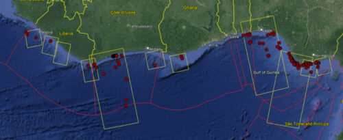
Illegal, unreported and unregulated (IUU) fishing continues to threaten ecosystems, markets and indigenous ways of life. Nowhere is this truer than in West Africa, where, in 2021, alongside Trygg Mat Tracking we partnered with the governments of Senegal, Côte d’Ivoire and Ghana along with the Fisheries Committee for the West Central Gulf of Guinea to pilot our new Vessel Viewer tool, with the aim of assisting States in the fight against illegal fishing through stronger port controls. Ports are often the last checkpoint where fish can be clearly linked to the vessel that caught it, and they offer one of the best and most cost-effective opportunities to identify and deter illegal fishing. Vessel Viewer provides data on a vessel’s identity, fishing activity, transshipment and port visits. This allows authorities to identify and cross-check relevant, absent or false information to inform risk-based decision making and target their inspection and enforcement efforts where they can have the greatest effect. Kenya has also joined in this partnership, and we’re hopeful its use will expand across Africa, indeed globally, so the tool can provide ubiquitous support, especially where enforcement resources are thin.
Building on Vessel Viewer technology—and keeping with our mission to remove IUU fishing incentives and give illegal operators fewer places to hide—we were proud to partner this year with Oceana, Trygg Mat Tracking, and the Ocean Risk and Resilience Action Alliance on the development of a new tool that will provide insurance underwriters with vessel history details that alert them to the risk of a vessel having engaged in illegal activity. Illegal operators put the entire industry and ways of life in jeopardy, so the response of denying them insurance is only fitting. The tool was announced at a high-level roundtable at the UN Climate Change Conference to help advance efforts to galvanize insurers and other actors in the fight against IUU fishing.
Bringing equity, accountability and equilibrium to commercial fishing is key to the Ocean Decade. Our work on the frontier of big data links us to an important partnership with the UN Food and Agricultural Organization (FAO), where we are building on earlier collaborations and assisting FAO in the decade endorsed action “Digital innovation Hand-in-Hand with fisheries and ecosystems scientific monitoring”. Our focus includes the 2019 Global Atlas of AIS-based Fishing Activity, which we are updating with more complete data by drawing on global feeds of satellite radar and optical imagery, allowing direct detection of fishing vessels even if they have shut off the broadcast of their GPS position.
We know the world lacks access to important data. To compound this problem, we are often unable to understand what we’re seeing when we do have access, because gaps and lack of integration in the data prevent us from grasping issues in their full scope. We are working to make our world-class vessel activity, apparent fishing data and analysis tools as widely available as possible. We’re developing new and better ways that our data can feed into and integrate automatically with other platforms—aiding new collaborations, energizing shared workspaces and increasing a web of information that is user-friendly and democratic.
A wave of transparency in Latin America
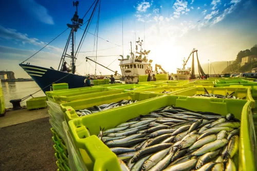
Open and shared data is foundational to the achievements of the past year. We have made progress and created important momentum globally, but are particularly proud of the leadership shown by States in Latin America, which continue to power a wave of transparency. Ecuador and Brazil have followed through on commitments to greater transparency in fisheries governance by making their vessel monitoring system (VMS) data publicly available on our map, and Belize and Costa Rica have committed to this step as well. There is a halo of information now around South and Central America that we want the rest of the world to mimic. Using our data and tools remains one of the most cost-effective and efficient ways that governments can reach their marine conservation goals. Ecuador, adjacent to some of the most valuable fisheries in the world, now has 700 vessels on our map, and this will only give strength to the Ecuadorian partnership with Canada’s Dark Vessel Detection program. The integration of Brazil’s VMS data with our platform brought the activity of more than 1,400 vessels in its national fleet into public view. The Brazilian tuna industry, led by the Atlantic Alliance for Sustainable Tuna and supported by Oceana, Global Fishing Watch, Projeto Albatroz, Pró-Tamar Foundation, the Rural Federal University of Pernambuco and Paiche Consultoria, won the 2021 Tuna Awards for its Open Tuna initiative to modernize data collection and bolster transparent traceability, using our tools with an aim of making sure its tuna industry is sustainable into the future.
Partnerships to extend impact
Collaboration with others continues to provide some of the richest avenues for our work. Our partnership with the United States Coast Guard continues to reap benefits and support enforcement on the water. The United States Southern Command, or SOUTHCOM, signed a partnership agreement with Global Fishing Watch, using our public vessel data and analysis to promote collaboration and stronger maritime surveillance across their Central and South American partnerships.
We provided analysis to assist a significant Associated Press investigation into the activities of the jumbo squid fleet in the Southeast Pacific. Through publication of our own monthly squid reports, we brought a spotlight and keen analytical tools to this important fishery, quantifying activity and identifying vessels that operated without transmitting their positions. We also pointed out those with a history of association with illegal activity. Our reports brought new monitoring to this massive extractive activity off the western coast of South America, and created actionable data to aid authorities in their decisions about targeted inspections, compliance enforcement and fisheries policy.
Co-hosted with the U.S. Defense Innovation Unit, we tapped the power of the hive mind with our xVIEW3 Challenge. Satellite radar technology can penetrate clouds and darkness to identify large metal vessels and the contest sought entries containing algorithms that can automatically detect vessels that do not publicly broadcast their position. Winners will be announced in the new year and we expect their contributions will help greatly in our ongoing work to reveal vessels operating in the shadows.
Research for scaling up and looking ahead
In 2020, Global Fishing Watch revealed one of the largest known cases of illegal fishing, with more than 900 fishing vessels originating from China fishing illegally in North Korean waters and thousands of North Korean vessels fishing in Russian waters. We revealed these vessels using a novel combination of satellite radar, nighttime and daytime optical imagery and automatic identification system, or AIS, data.
This year, the research team has been busy working to apply these same technologies globally. That is, we are going to use multi-sensor satellite technologies and machine learning to reveal vessels that do not publicly broadcast their location or appear in public monitoring systems, across the entire globe. We are now processing petabytes (1 petabyte = 1 million gigabytes) of optical and radar imagery—data sources hundreds of times larger than our current AIS data. In the next year, we will start to see the results of this work and a public layer produced in our map.
We have also made a number of advances behind the scenes, drawing in new data and building technology that will drive greater reach and impact. This work includes an updated risk model of forced labor on fishing vessels, and analysis comparing gaps in vessel transmissions to vessel locations relative to boundaries like MPAs, building on our research published in the PNAS Journal last year. We are also working on a new, global database of vessels that will identify ownerships and authorizations of vessels around the globe. We are developing an application programming interface, or API, portal that will allow for automated connection of the Global Fishing Watch data to other systems. The first to test our API is World Resources Institute’s newly released Ocean Watch initiative.
To ensure new streams of data can be widely used to help inform management, we’ll be taking forward the joint analytical cell (JAC), established in 2021 by Global Fishing Watch, Trygg Mat Tracking and the International Monitoring, Control and Surveillance Network as a collaborative effort designed to harness the complementary information gathering and analytical capabilities, fisheries intelligence tools and databases, and international partnerships of the three founding organizations. Skylight and C4ADS are expected to be early contributors to the JAC.
Our team is also exploring new areas of research, analyzing the impacts of all vessels at sea, and not just fishing vessels. There is no longer any question that transparency can support efforts to tackle IUU fishing and improve ocean stewardship. We also believe that leaps in machine learning and further refinements in how we process data will give the world better information on vessels that might be at risk of human rights violations and the use of forced labor . As we enter 2022, we will be exploring how transparency can power governance needed to solve other challenges facing our ocean. We are certain we can drive greater engagement with coastal and flag States and civil society toward transparency goals because we have already seen that wave building. Our focus in the future will encompass a fuller view of all human activity on the water and impacts to biodiversity and climate.
Like surfers paddling to the lineup, we see waves of big data coming, and a future full of possibilities.
Tony Long is CEO with Global Fishing Watch.